GlobalChangeBiology: Difference between revisions
(→Author) |
m (moved Case studies/GlobalChangeBiology to GlobalChangeBiology: Seems a more standard practice through the wiki.) |
||
| (18 intermediate revisions by the same user not shown) | |||
| Line 3: | Line 3: | ||
Analytical tools that provide a synthesis of ecological data are increasingly needed to design and maintain sustainable agroecosystems increasingly disrupted by global change in the form of agro-technical inputs, invasive species, and climate change. A key issue at the interface between global change and biological systems (i.e., global change biology) is the increasing problem of invasive species, whose worldwide annual cost exceeds that of natural disasters (Ricciardi'' et al.'' 2011). A variety of climate matching models have been used to predict the potential distribution of invaders, but there have been few attempts to include biotic interactions in addition to abiotic drivers into such models. The [https://sites.google.com/site/globalchangebiology/ GlobalChangeBiology project] analyzed the potential distribution and relative abundance of invasive species of global relevance using weather-driven physiologically-based demographic models in a GRASS GIS context to provide a more quantitative and realistic approach for assessing the risks posed by biological invasions. The long-term goal of the project is to develop interdisciplinary tools for the analysis of ecological and agro-ecological problems that will increase in the face of global change. In this case study, two examples of invasive species analysis are given to illustrate capabilities of GRASS. | Analytical tools that provide a synthesis of ecological data are increasingly needed to design and maintain sustainable agroecosystems increasingly disrupted by global change in the form of agro-technical inputs, invasive species, and climate change. A key issue at the interface between global change and biological systems (i.e., global change biology) is the increasing problem of invasive species, whose worldwide annual cost exceeds that of natural disasters (Ricciardi'' et al.'' 2011). A variety of climate matching models have been used to predict the potential distribution of invaders, but there have been few attempts to include biotic interactions in addition to abiotic drivers into such models. The [https://sites.google.com/site/globalchangebiology/ GlobalChangeBiology project] analyzed the potential distribution and relative abundance of invasive species of global relevance using weather-driven physiologically-based demographic models in a GRASS GIS context to provide a more quantitative and realistic approach for assessing the risks posed by biological invasions. The long-term goal of the project is to develop interdisciplinary tools for the analysis of ecological and agro-ecological problems that will increase in the face of global change. In this case study, two examples of invasive species analysis are given to illustrate capabilities of GRASS. | ||
GRASS GIS was used in the GlobalChangeBiology project to map the potential geographic distribution and relative abundance (i.e., measures of invasiveness) of two invasive insect pests of global relevance: the Mediterranean fruit fly ''Ceratitis capitata'' (medfly; [http://link.springer.com/content/pdf/10.1007%2Fs10530-011-9937-6 Gutierrez & Ponti 2011], Open Access) and the light brown apple moth ''Epiphyas postvittana'' (LBAM; [http://link.springer.com/content/pdf/10.1007%2Fs10530-010-9725-8 Gutierrez'' et al.'' 2010], Open Access). Species invasiveness was projected using multitrophic weather-driven physiologically-based demographic models that also simulate host plant dynamics and hence plant-herbivore interactions. The GRASS-based GIS used in the project was initially developed by Luigi Ponti during his postdoctoral tenure at the University of California, Berkeley with the aim of replacing and improving existing functionality based on proprietary GIS software. Going the GRASS way proved extremely rewarding as it allowed developing a flexible and efficient geospatial tool that can be tuned to perform batch data analysis while at the same time producing publication-quality maps. In addition to mapping, GRASS allows further GIS (see Neteler'' et al.'' 2012) and statistical analysis to be implemented via the interface between GRASS and the free software environment for statistical computing and graphics R ([http://www.osgeo.org/files/journal/final_pdfs/OSGeo_vol1_GRASS-R.pdf Bivand 2007]). | GRASS GIS was used in the GlobalChangeBiology project to map the potential geographic distribution and relative abundance (i.e., measures of invasiveness) of two invasive insect pests of global relevance: the Mediterranean fruit fly ''Ceratitis capitata'' (medfly; [http://link.springer.com/content/pdf/10.1007%2Fs10530-011-9937-6 Gutierrez & Ponti 2011], Open Access) and the light brown apple moth ''Epiphyas postvittana'' (LBAM; [http://link.springer.com/content/pdf/10.1007%2Fs10530-010-9725-8 Gutierrez'' et al.'' 2010], Open Access). Species invasiveness was projected using multitrophic weather-driven physiologically-based demographic models that also simulate host plant dynamics and hence plant-herbivore interactions. The GRASS-based GIS used in the project was initially developed by Luigi Ponti during his postdoctoral tenure at the University of California, Berkeley with the aim of replacing and improving existing functionality based on proprietary GIS software. Going the GRASS way proved extremely rewarding as it allowed developing a flexible and efficient geospatial tool that can be tuned to perform batch data analysis while at the same time producing publication-quality maps. In addition to mapping, GRASS allows further GIS (see [http://gis.cri.fmach.it/uploads/neteler2012_grass_gis_proof.pdf Neteler'' et al.'' 2012]) and statistical analysis to be implemented via the interface between GRASS and the free software environment for statistical computing and graphics R ([http://www.osgeo.org/files/journal/final_pdfs/OSGeo_vol1_GRASS-R.pdf Bivand 2007]). | ||
=== Mediterranean fruit fly === | === Mediterranean fruit fly === | ||
Medfly is of East African origins | Medfly is a serious cosmopolitan pest of East African origins that was first detected in California in 1975, but persistent measurable populations of the pest have not been subsequently found. Yet a large-scale detection/eradication campaign has since been place in the absence of sound knowledge of the fly’s potential invasiveness and geographic distribution. Our analysis suggests that temperatures are unfavorable for medfly in much of California and hence questions the scientific basis for the ongoing eradication program (Fig. 1). | ||
| Line 16: | Line 16: | ||
=== Light brown apple moth === | === Light brown apple moth === | ||
Native to Australia, LBAM was first found in California in 2006 and has thereafter spread to coastal areas of the state causing no economic damage. In 2007, however, a controversial program of aerial sprays was begun over urban and suburban areas to eradicate LBAM based on its predicted wide geographic range (including much of Arizona and California and the southern half of the US) and consequent economic losses estimated by the United States Department of Agriculture (USDA). The predictions of our mechanistic model differ markedly from those made by USDA using on a simple degree-day accumulation model, and show that the potential distribution of LBAM in California is, as observed, largely restricted to near coastal areas (Fig. 2). | Native to Australia, LBAM was first found in California in 2006 and has thereafter spread to coastal areas of the state causing no economic damage despite its broad host range. In 2007, however, a controversial program of aerial sprays was begun over urban and suburban areas to eradicate LBAM based on its predicted wide geographic range (including much of Arizona and California and the southern half of the US) and consequent economic losses estimated by the United States Department of Agriculture (USDA; see [http://www.aphis.usda.gov/plant_health/plant_pest_info/lba_moth/downloads/lbameconomicanalysis.pdf Fowler et al. 2009]). The predictions of our mechanistic model differ markedly from those made by USDA using on a simple degree-day accumulation model, and show that the potential distribution of LBAM in California is, as observed, largely restricted to near coastal areas (Fig. 2). Our analysis of LBAM in California contributed to switch the LBAM eradication program to one of containment. | ||
[[Image:Lbam.png|640px]] | [[Image:Lbam.png|640px]] | ||
'''Fig. 2.''' Mapping of average simulated light brown apple moth populations (larval days during 1996–2005) in Arizona and California: (a) locations where the moth has been recovered in northcentral California (from Fowler et al. 2009) and (b) the simulated average distribution below 750 m. | '''Fig. 2.''' Mapping of average simulated light brown apple moth populations (larval days during 1996–2005) in Arizona and California: (a) locations where the moth has been recovered in northcentral California (from [http://www.aphis.usda.gov/plant_health/plant_pest_info/lba_moth/downloads/lbameconomicanalysis.pdf Fowler et al. 2009]) and (b) the simulated average distribution below 750 m. | ||
=== The GlobalChangeBiology project === | |||
The GlobalChangeBiology project is a Marie Curie International Reintegration Grant (funded by the Seventh Framework Program of the European Union) that was awarded to Luigi Ponti and hosted by the [http://utagri.enea.it/ AGRI technical unit] of ENEA (ENEA is the Italian national agency for new technologies, energy and sustainable economic development) led by Dr. Massimo Iannetta. The project involved collaboration with Prof. Andrew Paul Gutierrez (Professor Emeritus at the at the University of California, Berkeley and CEO of the non profit organization [http://cnr.berkeley.edu/casas/ CASAS Global]) and Dr. Markus Neteler (Head of [http://gis.cri.fmach.it/ GIS and Remote Sensing unit] at Fondazione Edmund Mach – Centro Ricerca e Innovazione). Thanks to the GlobalChangeBiology project, ENEA now deploys an ecosystem modeling/GIS tool that was not available in Europe prior to the project and can be harnessed to devise scientifically-sound response strategies to global change in agriculture including the increasing problem of invasive species. GRASS is also helping the GlobalChangeBiology project establish a direct link between agroecosystem analysis and remote sensing data so as to bridge the gap between bottom-up and top-down GIS approaches for assessing on-ground ecosystem-level problems such as invasive species. Last but not least, GRASS comes with incredibly strong community support, and this allowed the development of the GRASS-based GIS used in this project to benefit from authoritative hints and insight provided by top-level professionals working in universities, governmental agencies, and commercial settings worldwide. This was critical especially in the initial phase of migrating GIS functionality from proprietary software to GRASS. | |||
{|class="wikitable" | |||
|[[Image:ENEA_logo.gif|100px|link=http://utagri.enea.it/]] | |||
|[[Image:Uc-berkeley_logo.jpg|100px|link=http://ourenvironment.berkeley.edu/]] | |||
|[[Image:CASAS_logo.png|100px|link=http://cnr.berkeley.edu/casas/]] | |||
|- | |||
|[[Image:Marie-Curie_logo.jpg|100px|link=http://ec.europa.eu/research/mariecurieactions/]] | |||
|[[Image:FP7-people_logo.jpg|100px|link=http://cordis.europa.eu/fp7/home_en.html]] | |||
= | |[[Image:Eu_emblem.gif|100px|link=http://europa.eu/index_en.htm]] | ||
|} | |||
== Author == | == Author == | ||
| Line 35: | Line 50: | ||
Luigi Ponti | Luigi Ponti | ||
{| | {| class="wikitable" cellpadding="30" style="border: 1px solid darkgray;" | ||
|- | |- style="border: 1px solid darkgray;" | ||
| | | | ||
[http://utagri.enea.it/utagri-eco Laboratorio Gestione Sostenibile degli Agro-Ecosistemi] | [http://utagri.enea.it/utagri-eco Laboratorio Gestione Sostenibile degli Agro-Ecosistemi] | ||
ENEA Centro Ricerche Casaccia | ENEA Centro Ricerche Casaccia, Via Anguillarese 301 | ||
Via Anguillarese 301 | |||
00123 Roma | 00123 Roma | ||
| Line 52: | Line 64: | ||
|| | || | ||
[http://cnr.berkeley.edu/casas/ CASAS, Center for the Analysis of Sustainable Agricultural Systems] | [http://cnr.berkeley.edu/casas/ CASAS, Center for the Analysis of Sustainable Agricultural Systems] | ||
Latest revision as of 19:39, 6 December 2012
Assessing the invasiveness of exotic species using ecosystem models and GRASS GIS
Analytical tools that provide a synthesis of ecological data are increasingly needed to design and maintain sustainable agroecosystems increasingly disrupted by global change in the form of agro-technical inputs, invasive species, and climate change. A key issue at the interface between global change and biological systems (i.e., global change biology) is the increasing problem of invasive species, whose worldwide annual cost exceeds that of natural disasters (Ricciardi et al. 2011). A variety of climate matching models have been used to predict the potential distribution of invaders, but there have been few attempts to include biotic interactions in addition to abiotic drivers into such models. The GlobalChangeBiology project analyzed the potential distribution and relative abundance of invasive species of global relevance using weather-driven physiologically-based demographic models in a GRASS GIS context to provide a more quantitative and realistic approach for assessing the risks posed by biological invasions. The long-term goal of the project is to develop interdisciplinary tools for the analysis of ecological and agro-ecological problems that will increase in the face of global change. In this case study, two examples of invasive species analysis are given to illustrate capabilities of GRASS.
GRASS GIS was used in the GlobalChangeBiology project to map the potential geographic distribution and relative abundance (i.e., measures of invasiveness) of two invasive insect pests of global relevance: the Mediterranean fruit fly Ceratitis capitata (medfly; Gutierrez & Ponti 2011, Open Access) and the light brown apple moth Epiphyas postvittana (LBAM; Gutierrez et al. 2010, Open Access). Species invasiveness was projected using multitrophic weather-driven physiologically-based demographic models that also simulate host plant dynamics and hence plant-herbivore interactions. The GRASS-based GIS used in the project was initially developed by Luigi Ponti during his postdoctoral tenure at the University of California, Berkeley with the aim of replacing and improving existing functionality based on proprietary GIS software. Going the GRASS way proved extremely rewarding as it allowed developing a flexible and efficient geospatial tool that can be tuned to perform batch data analysis while at the same time producing publication-quality maps. In addition to mapping, GRASS allows further GIS (see Neteler et al. 2012) and statistical analysis to be implemented via the interface between GRASS and the free software environment for statistical computing and graphics R (Bivand 2007).
Mediterranean fruit fly
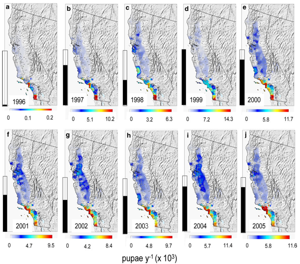
Medfly is a serious cosmopolitan pest of East African origins that was first detected in California in 1975, but persistent measurable populations of the pest have not been subsequently found. Yet a large-scale detection/eradication campaign has since been place in the absence of sound knowledge of the fly’s potential invasiveness and geographic distribution. Our analysis suggests that temperatures are unfavorable for medfly in much of California and hence questions the scientific basis for the ongoing eradication program (Fig. 1).
Fig. 1. Annual maps of simulated medfly pupae per tree per year across California during 1996–2005 (a–j). The vertical histogram in each subfigure represents the relative range of densities compared to the maximum during 1999.
Light brown apple moth
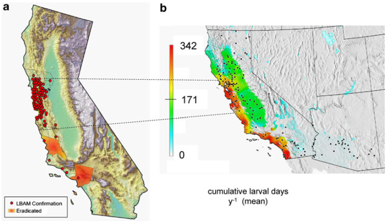
Native to Australia, LBAM was first found in California in 2006 and has thereafter spread to coastal areas of the state causing no economic damage despite its broad host range. In 2007, however, a controversial program of aerial sprays was begun over urban and suburban areas to eradicate LBAM based on its predicted wide geographic range (including much of Arizona and California and the southern half of the US) and consequent economic losses estimated by the United States Department of Agriculture (USDA; see Fowler et al. 2009). The predictions of our mechanistic model differ markedly from those made by USDA using on a simple degree-day accumulation model, and show that the potential distribution of LBAM in California is, as observed, largely restricted to near coastal areas (Fig. 2). Our analysis of LBAM in California contributed to switch the LBAM eradication program to one of containment.
Fig. 2. Mapping of average simulated light brown apple moth populations (larval days during 1996–2005) in Arizona and California: (a) locations where the moth has been recovered in northcentral California (from Fowler et al. 2009) and (b) the simulated average distribution below 750 m.
The GlobalChangeBiology project
The GlobalChangeBiology project is a Marie Curie International Reintegration Grant (funded by the Seventh Framework Program of the European Union) that was awarded to Luigi Ponti and hosted by the AGRI technical unit of ENEA (ENEA is the Italian national agency for new technologies, energy and sustainable economic development) led by Dr. Massimo Iannetta. The project involved collaboration with Prof. Andrew Paul Gutierrez (Professor Emeritus at the at the University of California, Berkeley and CEO of the non profit organization CASAS Global) and Dr. Markus Neteler (Head of GIS and Remote Sensing unit at Fondazione Edmund Mach – Centro Ricerca e Innovazione). Thanks to the GlobalChangeBiology project, ENEA now deploys an ecosystem modeling/GIS tool that was not available in Europe prior to the project and can be harnessed to devise scientifically-sound response strategies to global change in agriculture including the increasing problem of invasive species. GRASS is also helping the GlobalChangeBiology project establish a direct link between agroecosystem analysis and remote sensing data so as to bridge the gap between bottom-up and top-down GIS approaches for assessing on-ground ecosystem-level problems such as invasive species. Last but not least, GRASS comes with incredibly strong community support, and this allowed the development of the GRASS-based GIS used in this project to benefit from authoritative hints and insight provided by top-level professionals working in universities, governmental agencies, and commercial settings worldwide. This was critical especially in the initial phase of migrating GIS functionality from proprietary software to GRASS.

| ||

|

|

|
Author
Luigi Ponti
|
Laboratorio Gestione Sostenibile degli Agro-Ecosistemi ENEA Centro Ricerche Casaccia, Via Anguillarese 301 00123 Roma Italy |
CASAS, Center for the Analysis of Sustainable Agricultural Systems 37 Arlington Ave Kensington, CA 94707 USA |
References
Bivand R (2007) Using the R–Grass interface: current status. OSGeo Journal, 1, 36-38. (PDF)
Gutierrez AP, Ponti L (2011) Assessing the invasive potential of the Mediterranean fruit fly in California and Italy. Biological Invasions, 13, 2661-2676. (DOI | PDF)
Gutierrez AP, Mills NJ, Ponti L (2010) Limits to the potential distribution of light brown apple moth in Arizona-California based on climate suitability and host plant availability. Biological Invasions, 12, 3319-3331. (DOI | PDF)
Neteler M, Bowman MH, Landa M, Metz M (2012) GRASS GIS: a multi-purpose Open Source GIS. Environmental Modelling & Software, 31, 124-130. (DOI | PDF)
Ricciardi A, Palmer ME, Yan ND (2011) Should biological invasions be managed as natural disasters? Bioscience, 61, 312-317. (DOI)
