File:Flowacc nviz.png
Jump to navigation
Jump to search
No higher resolution available.
Flowacc_nviz.png (493 × 287 pixels, file size: 171 KB, MIME type: image/png)
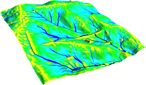
Flow accumulation(NC dataset) with Multiple Flow Direction:
# set computational region to map
g.region rast=elev_lid792_1m -p

# -f for MFD
r.watershed -f elevation=elev_lid792_1m accumulation=flowacc

# check map list
g.list rast

# show metadata
r.info flowacc

# nice perspective view
nviz elevation=elev_lid792_1m color=flowacc
File history
Click on a date/time to view the file as it appeared at that time.
| Date/Time | Thumbnail | Dimensions | User | Comment | |
|---|---|---|---|---|---|
| current | 07:33, 29 August 2011 | | 493 × 287 (171 KB) | Neteler (talk | contribs) | Flow accumulation(NC dataset) with Multiple Flow Direction: # set computational region to map g.region rast=elev_lid792_1m -p # -f for MFD r.watershed -f elevation=elev_lid792_1m accumulation=flowacc # check map list g.list rast # show metadata r.info |
You cannot overwrite this file.
File usage
The following page uses this file: