Hyperion: Difference between revisions
m (→Data Download) |
|||
| Line 1: | Line 1: | ||
== Hyperion Hyperspectral | == Hyperion Hyperspectral Data == | ||
[[File:eo1_satellite.jpg]] | [[File:eo1_satellite.jpg]] | ||
=== EO-1 platform === | === EO-1 platform === | ||
Revision as of 06:39, 2 December 2023
Hyperion Hyperspectral Data
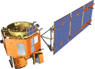
EO-1 platform
The NASA EO-1 satellite was launched on November 21, 2000 as part of a one-year technology validation/demonstration mission (EO-1 Mission Page).
The mission was to use the Advanced Land Imager (ALI) instrument on EO-1 to validate and demonstrate technology for the Landsat Data Continuity Mission (LDCM).
The original EO-1 Mission was successfully completed in November 2001. As the end of the Mission approached, the remote sensing research and scientific communities expressed high interest in continued acquisition of image data from EO-1. Based on this user interest and willingness to assist in funding continued operations, an agreement was reached between NASA and the USGS to allow continuation of the EO-1 Program as an Extended Mission.
On February 22nd, 2017, the Earth-Observing One (EO-1) satellite was decommissioned.
Sensors
- Advanced Land Imager (ALI)
- Hyperion
- Linear Etalon Imaging Spectrometer Array (LEISA) Atmospheric Corrector (LAC)
The EO-1 Extended Mission was chartered to collect and distribute ALI multispectral and Hyperion hyperspectral products in response to Data Acquisition Requests (DARs). Under the Extended Mission provisions, image data acquired by EO-1 were archived and distributed by the USGS Center for Earth Resources Observation and Science (EROS) and placed in the public domain.
Data Download
Level 1 GST is terrain corrected and provided in 16-bit radiance values. The data are available in Geographic Tagged Image-File Format (GeoTIFF) and are distributed via download at no charge through either EarthExplorer or USGS Global Visualization Viewer (GloVis).
| Map projection | UTM (default zone of the scene center coordinates) |
| Horizontal Datum | WGS84 |
| Resampling method | CC (cubic convolution) |
| Image orientation | Map (north up) |
| Pixel size | 30 meter (10 meter pan band) |
| Format | GeoTIFF |
| Output media | Download (no charge) |
