FOSS4G2007 IntegrationShowcase: Difference between revisions
Jump to navigation
Jump to search
(more ideas) |
(data set clarification) |
||
| Line 1: | Line 1: | ||
== Competitive FOSS4G2007 showcase == | |||
At FOSS4G2007, a showcase is planned to see how well the OSGeo (and non-OSGeo) software performs, based on the same dataset - to see each project handles the same information. | At FOSS4G2007, a showcase is planned to see how well the OSGeo (and non-OSGeo) software performs, based on the same dataset - to see each project handles the same information. | ||
For more information, visit the following page: | For more information, visit the following page: | ||
http://wiki.osgeo.org/index.php/FOSS4G2007_IntegrationShowcase | http://wiki.osgeo.org/index.php/FOSS4G2007_IntegrationShowcase | ||
'''Data sources:''' | |||
* Original data (recommended): http://wiki.osgeo.org/index.php/Canadian_Geodata | |||
* Data on PostGIS server: see http://wiki.osgeo.org/index.php/FOSS4G2007_IntegrationShowcase | |||
== GRASS 6.3 == | == GRASS 6.3 == | ||
| Line 33: | Line 40: | ||
''Please continue and expand...'' | ''Please continue and expand...'' | ||
=== Import of original data sets === | |||
... | |||
=== Data processing in GRASS === | === Data processing in GRASS === | ||
| Line 40: | Line 51: | ||
** vector networking, LRS | ** vector networking, LRS | ||
** ... | ** ... | ||
* QGIS | |||
* JavaGRASS/uDig | |||
=== Data export === | === Data export === | ||
Latest revision as of 20:24, 23 August 2007
Competitive FOSS4G2007 showcase
At FOSS4G2007, a showcase is planned to see how well the OSGeo (and non-OSGeo) software performs, based on the same dataset - to see each project handles the same information.
For more information, visit the following page:
http://wiki.osgeo.org/index.php/FOSS4G2007_IntegrationShowcase
Data sources:
- Original data (recommended): http://wiki.osgeo.org/index.php/Canadian_Geodata
- Data on PostGIS server: see http://wiki.osgeo.org/index.php/FOSS4G2007_IntegrationShowcase
GRASS 6.3
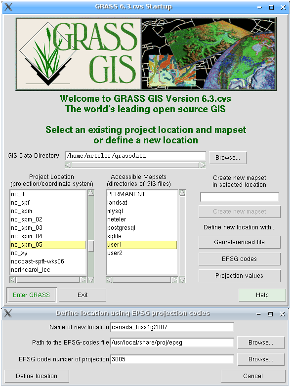
Startup
Definition of a new GRASS location using the given EPSG code 3005:

(see also larger screenshot)
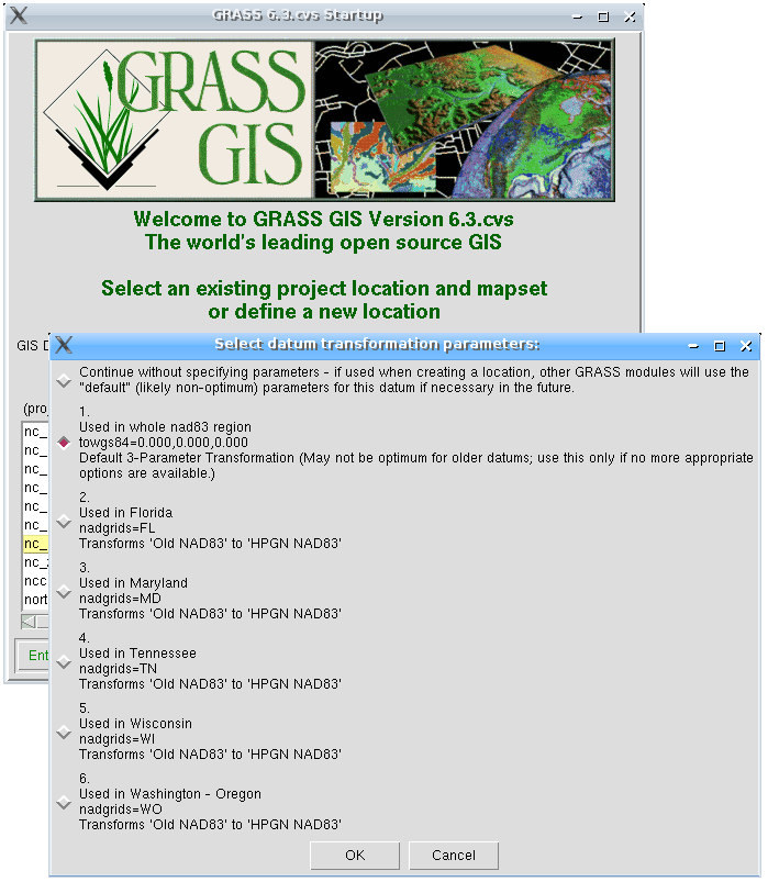
Selection of geodetic datum for EPSG code 3005:

(see also larger screenshot)
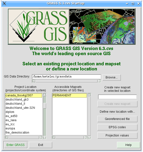
New location 'canada_foss4g2007' created, ready to start GRASS:

(see also larger screenshot)
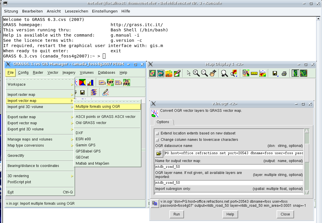
Import of map 'ntdb_road_50' from PostGIS server

(see also larger screenshot)
For us friends of command line:
  v.in.ogr dsn="PG:host=office.refractions.net port=20543 dbname=foss user=foss password=foss4g07" \
           output=ntdb_road_50 layer=ntdb_road_50 type=line
Please continue and expand...
Import of original data sets
...
Data processing in GRASS
- visualization
- analysis
- distances
- vector networking, LRS
- ...
- QGIS
- JavaGRASS/uDig
Data export
- KML
- DXF