File:Comparison Paris.png
No higher resolution available.
Comparison_Paris.png (640 × 386 pixels, file size: 15 KB, MIME type: image/png)
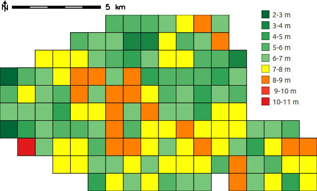
Maximum deviation of the Paris OpenStreetMap dataset from the IGN dataset on a square grid with 1km x 1km cell size.
File history
Click on a date/time to view the file as it appeared at that time.
| Date/Time | Thumbnail | Dimensions | User | Comment | |
|---|---|---|---|---|---|
| current | 09:28, 28 September 2016 | | 640 × 386 (15 KB) | ⚠️Marco.minghini (talk | contribs) | image resized |
| 09:19, 28 September 2016 |  | 854 × 516 (17 KB) | ⚠️Marco.minghini (talk | contribs) | Maximum deviation of the Paris OpenStreetMap dataset from the IGN dataset on a square grid with 1km x 1km cell size. |
You cannot overwrite this file.
File usage
The following page uses this file: