Linear Reference System: Difference between revisions
(+intro) |
No edit summary |
||
| Line 8: | Line 8: | ||
* GRASS GIS Manual: {{cmd|lrs}} - Linear Reference System Tutorial | * GRASS GIS Manual: {{cmd|lrs}} - Linear Reference System Tutorial | ||
* R. Blazek: [http://web.archive.org/web/20070225185824/http://www.j-geoinfo.net/Content/fulmar05/IJG_095-100.pdf Introducing the Linear Reference System in GRASS] (March 2005, Int'l Journal of Geoinformatics, Vol. 1(3), pp. 95-100) | * R. Blazek: [http://web.archive.org/web/20070225185824/http://www.j-geoinfo.net/Content/fulmar05/IJG_095-100.pdf Introducing the Linear Reference System in GRASS] (March 2005, Int'l Journal of Geoinformatics, Vol. 1(3), pp. 95-100) | ||
<!-- also: http://creativecity.gscc.osaka-cu.ac.jp/IJG/article/download/320/321 --> | |||
* R. Blazek: [http://gisws.media.osaka-cu.ac.jp/grass04/viewpaper.php?id=50 Introducing the Linear Reference System in GRASS] (Sept 2004, Conference Paper) | * R. Blazek: [http://gisws.media.osaka-cu.ac.jp/grass04/viewpaper.php?id=50 Introducing the Linear Reference System in GRASS] (Sept 2004, Conference Paper) | ||
* PostGIS Reference, Chapter 6 [http://postgis.refractions.net/docs/reference.html#Linear_Referencing PostGIS: Linear Referencing] | * PostGIS Reference, Chapter 6 [http://postgis.refractions.net/docs/reference.html#Linear_Referencing PostGIS: Linear Referencing] | ||
Latest revision as of 22:25, 1 February 2014
A Linear Referencing System (LRS) is a system where features (points or segments) are localized by a measure along a linear element (e.g., a vector line). The LRS can be used to reference events for any network of linear features, for example bus stops along roads, train stations along railways, water quality measurements along rivers, pipelines, electric and telephone lines, water and sewer networks. An event is defined in LRS by a route ID and a measure. A route is a path on the network, usually composed from more features in the input map. Events can be either points or lines (segments).
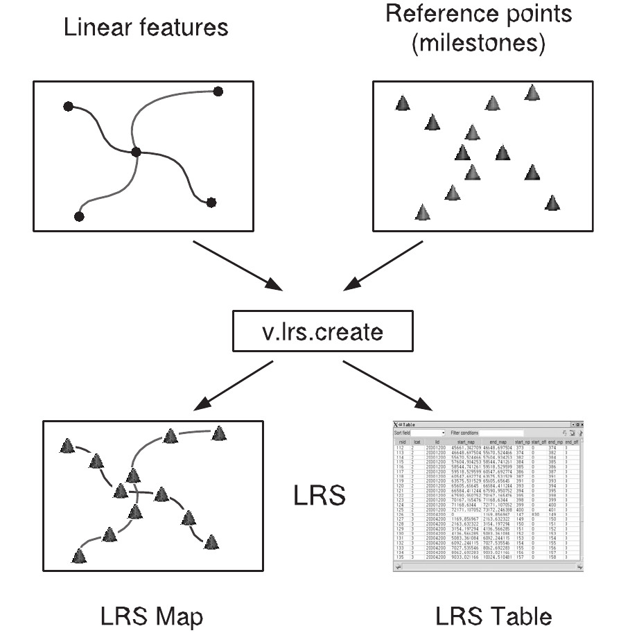
LRS is created from input lines and points in vector map. Points - MP (mileposts) must have attached attributes specifying line and distance. The distances from the beginning of the linear feature in real world are specified by MP+offset. Typically, MP is in kilometers and offset in meters.

- General intro: Linear_Reference_System (Wikipedia)
- GRASS GIS Manual: lrs - Linear Reference System Tutorial
- R. Blazek: Introducing the Linear Reference System in GRASS (March 2005, Int'l Journal of Geoinformatics, Vol. 1(3), pp. 95-100)
- R. Blazek: Introducing the Linear Reference System in GRASS (Sept 2004, Conference Paper)
- PostGIS Reference, Chapter 6 PostGIS: Linear Referencing