Planetary mapping: Difference between revisions
Jump to navigation
Jump to search
m (update citation) |
|||
| Line 42: | Line 42: | ||
=== See also === | === See also === | ||
* Frigeri, A, Hare, T, Neteler, M., Coradini, A, Federico, C, Orosei, R. (2011). ''A research environment for digital planetary data processing and mapping using ISIS and GRASS GIS''. | * Frigeri, A, Hare, T, Neteler, M., Coradini, A, Federico, C, Orosei, R. (2011). ''A research environment for digital planetary data processing and mapping using ISIS and GRASS GIS''. Planetary and Space Science, 59(11-12), pp.1265-1272 [ [http://dx.doi.org/10.1016/j.pss.2010.12.008 DOI] | [http://gis.cri.fmach.it/uploads/frigeri2011_isis_grass.pdf PDF] ] | ||
* ... | * ... | ||
[[Category:Applications]] | [[Category:Applications]] | ||
[[Category:Documentation]] | [[Category:Documentation]] | ||
Revision as of 19:55, 15 December 2011
GIS Support
- GRASS lat/lon regions may be used as 0-360 longitude, not just 180 east+west.
- You can set and add custom ellipsoids, see the g.setproj module. Permanently adding custom ellipsoids can be done by hand, the config tables for that are plain self-documenting text files, so reasonably easy to edit. We would of course be happy to include standard planetary ellipsoids along with future versions GRASS. An ellipse table with planetary spheroids (to put as $GISBASE/etc/*.table files) is available here.
Open Issues
- r.out.gdal exports 'unknown' ellipsoids / datums, and also the reference meridian is named 'Greenwich'
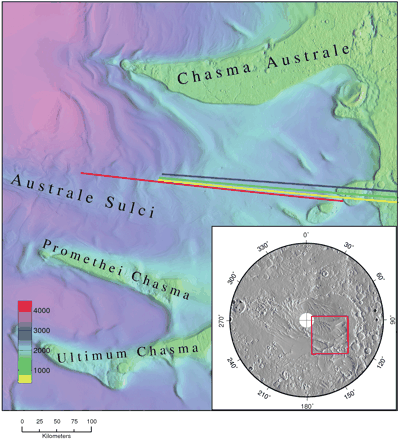
Example of the use of GRASS GIS in Planetary Research
GRASS ps.map output as published in an article in the journal Science.

Data
Data summary (1999):
http://publish.uwo.ca/~pjstooke/mapsummy.txt
Modules
- r.in.gdal will handle HDF and netCDF and many many more formats
- r.in.bin will load raw binary data
- see also the GRASS and GMT wiki page for interfacing with GMT Mapping Tools
Mars topography
See tutorial in GRASSNews volume 1:
- Global dataset of bathymetry and topography. GRASS Newsletter, 1:8-11, August 2004. ISSN 1614-8746.