Search results
Jump to navigation
Jump to search
Page title matches
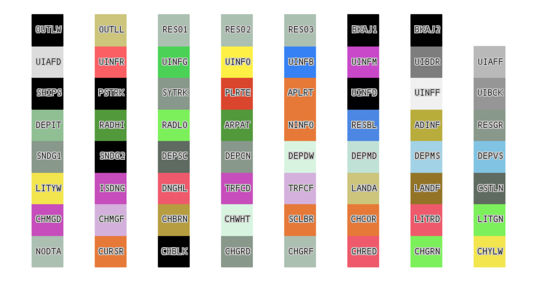 S-52 spec colors (mode=BRIGHT) color chart ...(1,046 × 549 (68 KB)) - 15:48, 2 June 2008
 (1,024 × 768 (881 KB)) - 05:06, 27 October 2009
 (1,024 × 768 (1.09 MB)) - 05:10, 27 October 2009


Page text matches
- == Official colors == ...1 KB (160 words) - 07:59, 28 January 2015
- S-52 spec colors (mode=BRIGHT) color chart ...(1,046 × 549 (68 KB)) - 15:48, 2 June 2008
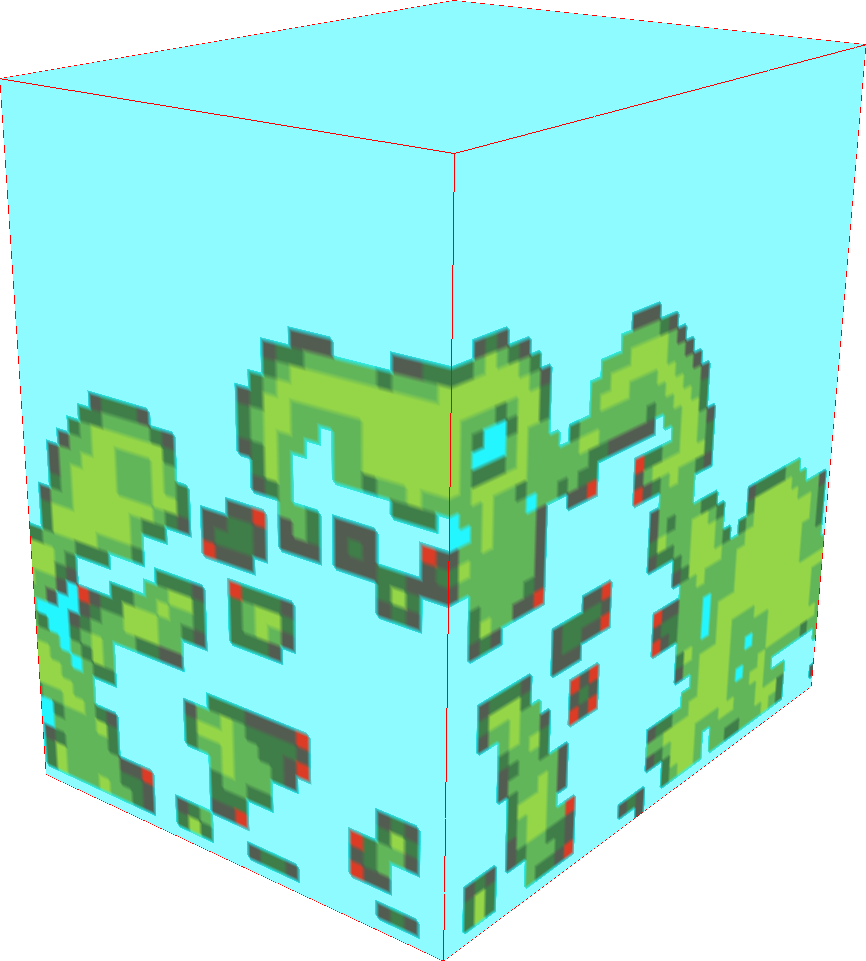 ...nce/absence in 3D. r3.forestfrag. Using slices in 3D view (NVIZ). Modified colors. ...(866 × 961 (147 KB)) - 21:05, 24 March 2017
- === GRASS-Wiki native colors === Should GRASS-Wiki pages wear GRASS' native colors? ...3 KB (416 words) - 10:46, 6 January 2013
- Shouldn't GRASS-Wiki pages wear GRASS' native colors? Have in mind the GRASS web-site, for example. Or some combination of whit ...217 bytes (31 words) - 14:57, 29 December 2012
- # assign colors r.colors aster_gdem color=terrain ...3 KB (454 words) - 07:48, 19 February 2013
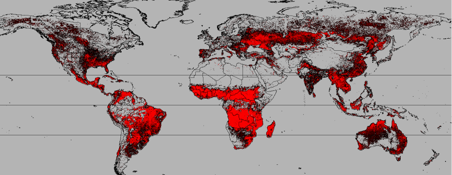 ...st-Different Global Fire Regimes, colored with Red-ONLY Repeat Burnability Colors. ...(900 × 348 (286 KB)) - 01:02, 27 April 2021
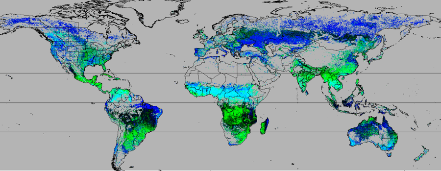 ...erent Global Fire Regimes, colored with Green-Blue ONLY Annual Seasonality Colors. ...(900 × 349 (293 KB)) - 01:03, 27 April 2021
- File:Grass logo mandrivia colors.png|mandrivia colors File:Grass colors 04.png|File:Grass colors 04 ...7 KB (1,090 words) - 12:31, 28 December 2015
- '''Q:''' Is it possible to display a vector (polygon) map so that colors are chosen based on an attribute column (not the "cat")? I assume this can ...521 bytes (93 words) - 09:38, 5 March 2014
- ...tp://trac.osgeo.org/grass/browser/grass/branches/releasebranch_6_4/lib/gis/colors/ SVN]) * {{cmd|r.colors}} ({{cmd|r.colors}} manual in GRASS 7 has colors tables embedded as well as the GUI dialog) ...6 KB (972 words) - 14:40, 10 August 2020
- == Testing colors for use in GRASS-Wiki == The official GRASS-GIS colors described in the [http://grasswiki.osgeo.org/wiki/GRASS_Logo GRASS Logo] pa ...7 KB (951 words) - 20:41, 25 January 2013
- * color tables and colors ...2 KB (287 words) - 02:04, 27 June 2017
- * Check how many categories (map colors) : ''8 colors'' ...5 KB (790 words) - 00:35, 7 December 2011
- ...ry and it's front-end wxNVIZ. Solution should be user configurable (fonts, colors, effects etc.) and multilanguage friendly. ...1 KB (219 words) - 16:57, 3 April 2010
- ...on NASA's GSFC OceanColor website's rules) and apply them with the {{cmd|r.colors}} module. r.colors $map rules=~/grass_addons/palette_chl_etc.gcolors ...1 KB (218 words) - 07:00, 6 September 2010
- * i.colors - see r.colors * p.colors - not ported ...11 KB (2,177 words) - 23:36, 15 December 2007
- ADDON_DIR="/path/to/grass/svn/grass-addons/raster/r.colors.tools/palettes" COLOR_DIR="$GISBASE/etc/colors/" ...5 KB (733 words) - 20:58, 13 September 2009
- r.colors -r "$map" # use standard colors === Set colors === ...7 KB (1,136 words) - 15:04, 20 December 2012
- ===Adjust colors=== ...d like so let's change them. In the <tt>Raster</tt> menu select <tt>Manage colors → Color Tables</tt>. ...14 KB (2,511 words) - 12:41, 8 August 2015


