Search results
Jump to navigation
Jump to search
Page title matches
- If you don't dispose of a fuel map, you can try to define the fuel by your expert judgement, with the help of this [http://www ...10h). The quantities moisture_1h and moisture_100h, respectively referring to 1 hour and 100 hours, are expressed likewise. ...5 KB (730 words) - 14:33, 25 March 2021
- ...ons. Most IRC servers do not require users to log in, but a user will have to set a nickname before being connected. ...annel ([irc://irc.libera.chat/grass #grass] on irc.libera.chat), feel free to join. There are many other geo related channels such as [irc://irc.libera.c ...5 KB (810 words) - 21:10, 1 August 2022
- == '''Q:''' How to create an elevation profile from intersecting shapefiles == '''A:''' You want to create an elevation profile for a walking track described in one file, when ...5 KB (842 words) - 01:59, 11 February 2016
- ...e preferences. You can also open several channels at time. It's convenient to automate the identification. -> Auto-url [someone please verify this, probably it's sufficient to type ...5 KB (788 words) - 23:12, 6 February 2010
- You have to have in your library the packages "gstat" and "spgrass6", you can download In GRASS we have a vector file named "giaciture_cat_clean3" and we want to do a prediction on this data... ...3 KB (506 words) - 09:49, 9 August 2013
Page text matches
- Pages concerning instruction how to migrate from ArcGIS to GRASS GIS, how to port scripts, differences between the packages and tips for users using bot ...8 members (0 subcategories, 0 files) - 15:12, 21 August 2015
- == How to add a new page? == To add a new page (after registration on this Wiki, see top-right corner), jus ...199 members (1 subcategory, 0 files) - 20:49, 8 March 2013
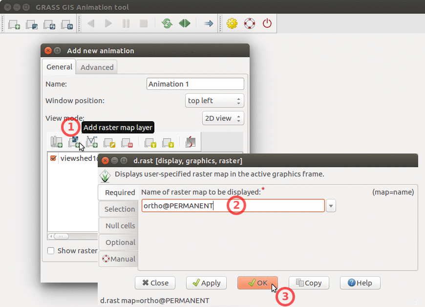 How to add base raster to Animation Tool ...(870 × 628 (251 KB)) - 20:54, 21 June 2017
- This category groups all the material about how to contribute to translation. ...2 members (0 subcategories, 0 files) - 18:01, 16 February 2015
- How to.. ...14 members (0 subcategories, 0 files) - 14:06, 7 August 2013
- The purpose of working groups is to coordinate the GRASS GIS community activities such as software development, == How to join == ...905 bytes (124 words) - 18:19, 10 October 2023
- Need to learn how software will operate. ...40 bytes (7 words) - 16:13, 28 August 2019
 how to use transifex 2 ...(535 × 149 (22 KB)) - 07:28, 10 March 2010
 how to use transifex 1 ...(455 × 181 (12 KB)) - 07:29, 10 March 2010
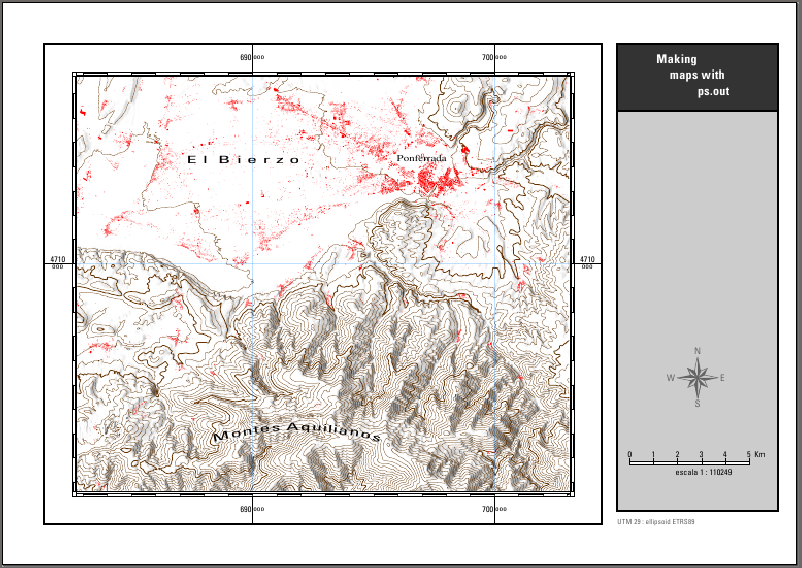 Third output of the how to ps.out ...(802 × 568 (351 KB)) - 21:45, 19 October 2010
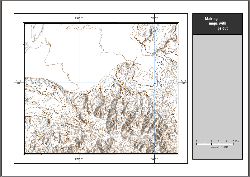 Second output example in the how to maps with ps.out ...(803 × 569 (314 KB)) - 21:04, 19 October 2010
- I'm a student and I want to learn how to use Grass ...50 bytes (12 words) - 12:29, 27 December 2014
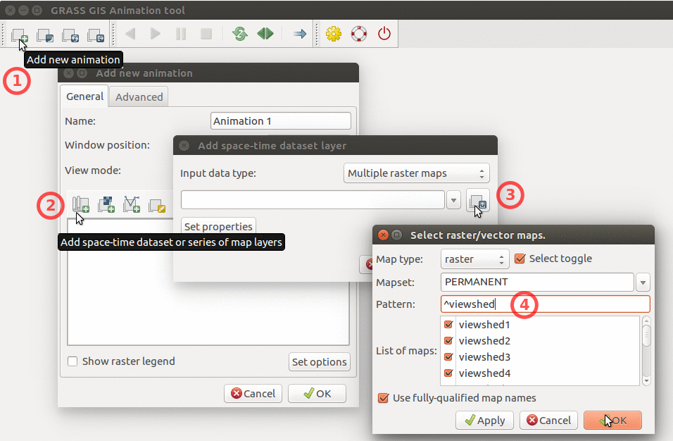 How to add multiple raster maps and filter them by name. ...(956 × 626 (320 KB)) - 20:54, 21 June 2017
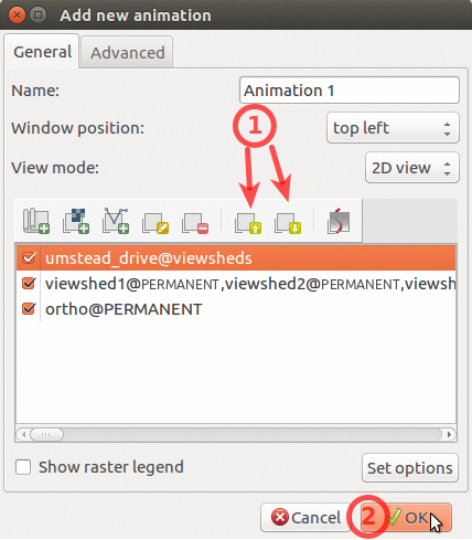 How to change order of layers in Animation Tool ...(428 × 489 (114 KB)) - 20:55, 21 June 2017
- === What is to be funded? === * car travel from Prague to Trento and back ...2 KB (214 words) - 22:34, 25 June 2016
- === What is to be funded? === === How many participants are expected? === ...2 KB (201 words) - 23:56, 19 February 2016
- '''Q:''' How to add points (centroids) to Polygons? '''A:''' ... quite easy to do in GRASS 6: [http://grass.itc.it/grass63/manuals/html63_user/v.category. ...395 bytes (67 words) - 17:59, 31 December 2013
- ...t lines into boundaries with {{cmd|v.type}}, but now, how to add centroids to turn them into areas? The lines look as follows. In {{cmd|v.digit}}: '''A:''' Run {{cmd|v.centroids}} to add centroid(s). ...407 bytes (69 words) - 16:59, 29 December 2011
- ...eferably by converting Shapely polygon to GRASS GIS vector format in order to use various tools within GRASS GIS? [[Category:Linking to other languages]] ...377 bytes (50 words) - 20:44, 8 November 2019
- '''Q:''' How to add multiple vertices to a line? ...243 bytes (41 words) - 20:25, 19 June 2012


