WxGUI Graphical Modeler: Difference between revisions
(Created page with 'center|thumb|400px|Experimental prototype of Graphical Modeler [[Image:wxGUI-modeler1.png|center|thumb|400px|Experimental prototype of Graphical Model…') |
m (remove hardcoded version specific urls, use latest version) |
||
| (99 intermediate revisions by 5 users not shown) | |||
| Line 1: | Line 1: | ||
'''Graphical Modeler''' is a GUI application which allows to create and manage complex models using easy-to-use interface. When performing analytical operations in GRASS, the operations are not isolated, but part of a chain of operations. Using Graphical Modeler, that chain of processes (ie. GRASS modules) can be wrapped into one process (ie. model). So it's easier to execute the model later with slightly different inputs or parameters. | |||
Graphical Modeler is release under [https://svn.osgeo.org/grass/grass/trunk/GPL.TXT GNU GPL] licence and the source is available from [https://svn.osgeo.org/grass/grass/trunk/gui/wxpython/gmodeler GRASS SVN repository]. | |||
See also {{cmd|wxGUI.gmodeler|desc=manual}} page and [http://trac.osgeo.org/grass/wiki/wxGUIDevelopment/Modeler wiki page] for development issues. | |||
__TOC__ | |||
The Graphical Modeler is '''available in GRASS 6.4.2+''' from the Layer Manager menu <code>File → Graphical modeler</code> or from the toolbar [[Image:modeler-main.png]]. | |||
In GRASS 7 the tool is also available from the command line as stand-alone application ({{cmd|g.gui.gmodeler}}). | |||
== Core features == | |||
The modeler currently allows to: | |||
:{| class="noborder" | |||
| style="vertical-align: top" | | |||
* define actions (GRASS commands) | |||
* define data items (raster, vector, 3D raster) | |||
* define relations between data and action items | |||
* define loops (series), conditions | |||
| | |||
* validate model | |||
* run model | |||
* store model settings to the file (GRASS Model File|*.gxm) | |||
* export model settings to Python script | |||
* export model to image | |||
|} | |||
== Gallery == | |||
<center> | |||
<gallery perrow=2 widths=400 heights=300> | |||
Image:wxGUI-modeler.png|Experimental prototype of Graphical Modeler | |||
Image:wxGUI-modeler1.png|Experimental prototype of Graphical Modeler | |||
Image:wxGUI-modeler2.png|Experimental prototype of Graphical Modeler | |||
Image:wxGUI-modeler3.png|Experimental prototype of Graphical Modeler | |||
Image:wxGUI-modeler-params.png|Graphical Modeler: run parametrized model | |||
Image:wxGUI-modeler-variables.png|Graphical Modeler: define model variables | |||
Image:wxGUI-modeler-loop.png|Graphical Modeler: define loops in the model | |||
Image:wxGUI-modeler-if-else.png|Graphical Modeler: define if/else statements in the model | |||
Image:wxGUI-modeler-if-else-0.png|Graphical Modeler: define if/else statements in the model - show properties | |||
Image:wxGUI-modeler-python-editor.png|Graphical Modeler: Python editor | |||
</gallery> | |||
</center> | |||
== Video tutorials == | |||
{{YouTube|lYrH3mioY7U|desc=Creating simple model}} | |||
{{YouTube|uNSwjSr90Lw|desc=Define intermediate data}} | |||
{{YouTube|j2UfmXbzvpg|desc=Model parametrization}} | |||
{{YouTube|RztxMXXtA0s|desc=Define variables}} | |||
{{YouTube|lzlpfXNbjuA|desc=Start model with data item}} | |||
{{YouTube|NeWavDSOhQk|desc=Creating simple model in wxGUI Graphical Modeler}} | |||
{{YouTube|Qxi_TblVYa0|desc=Start model with data, define relation manually}} | |||
{{YouTube|LFdn1VozMfo|desc=Creating model with series (loop) - static list of maps}} | |||
{{YouTube|b1QOBlT-oXE|desc=Creating model with series (loop) - dynamic list of maps}} | |||
{{YouTube|DTMmmcVpJKk|desc=Creating model which exports all GRASS vector maps from given mapset to PostGIS database}} | |||
{{YouTube|uStN3F6ZZoc|desc=Creating model which exports all GRASS vector maps from given mapset to PostGIS database (including schema) | |||
1) create schema with name of input mapset | |||
2) copy vector maps from selected mapset to the current and stores their attributes in SQLite database | |||
3) exports GRASS vector maps to the selected PostGIS database | |||
}} | |||
{{YouTube|1ACAV3ZZO9k|desc=WxGUI modeler - example of post-classification smoothing (remote sensing)}} | |||
{{YouTube|cCXkrGI20aw|desc=Python editor in wxGUI Graphical Modeler}} | |||
{{youTube|IhREmVtjlCI|desc=Vector overlay, area calculation}} | |||
{{youTube|0jkO-ih87mw|desc=Unsupervised classification performed using wxGUI Modeler}} | |||
== External links == | |||
Graphical modeller in action: | |||
* [http://gis-lab.info/qa/grass-modeller.html Brief description GRASS Graphical Modeler] (in Russian) | |||
Other products: | |||
* [http://www.clarklabs.org/products/product-features.cfm IDRISI Taiga Product Features] | * [http://www.clarklabs.org/products/product-features.cfm IDRISI Taiga Product Features] | ||
* [http://webhelp.esri.com/arcgisdesktop/9.3/index.cfm?TopicName=An_overview_of_ModelBuilder ArcGIS Model Builder] | * [http://webhelp.esri.com/arcgisdesktop/9.3/index.cfm?TopicName=An_overview_of_ModelBuilder ArcGIS Model Builder] | ||
* [http://blog.orfeo-toolbox.org/uncategorized/otb-inside-sextante-inside-qgis Sextante Modeler] | |||
== Acknowledgement == | |||
wxGUI Graphical Modeler was developed by Martin Landa with institutional support of the [http://www.cvut.cz Czech Technical University in Prague] | |||
{{WxGUI}} | {{WxGUI}} | ||
Latest revision as of 10:50, 4 December 2018
Graphical Modeler is a GUI application which allows to create and manage complex models using easy-to-use interface. When performing analytical operations in GRASS, the operations are not isolated, but part of a chain of operations. Using Graphical Modeler, that chain of processes (ie. GRASS modules) can be wrapped into one process (ie. model). So it's easier to execute the model later with slightly different inputs or parameters.
Graphical Modeler is release under GNU GPL licence and the source is available from GRASS SVN repository.
See also manual page and wiki page for development issues.
The Graphical Modeler is available in GRASS 6.4.2+ from the Layer Manager menu File → Graphical modeler or from the toolbar ![]() .
.
In GRASS 7 the tool is also available from the command line as stand-alone application (g.gui.gmodeler).
Core features
The modeler currently allows to:
- define actions (GRASS commands)
- define data items (raster, vector, 3D raster)
- define relations between data and action items
- define loops (series), conditions
- validate model
- run model
- store model settings to the file (GRASS Model File|*.gxm)
- export model settings to Python script
- export model to image
Gallery
-
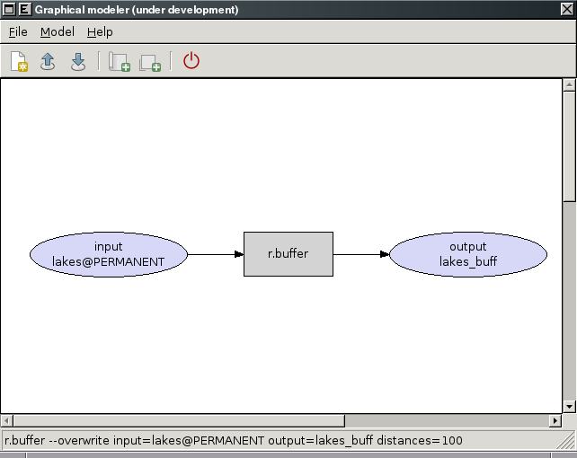
Experimental prototype of Graphical Modeler
-
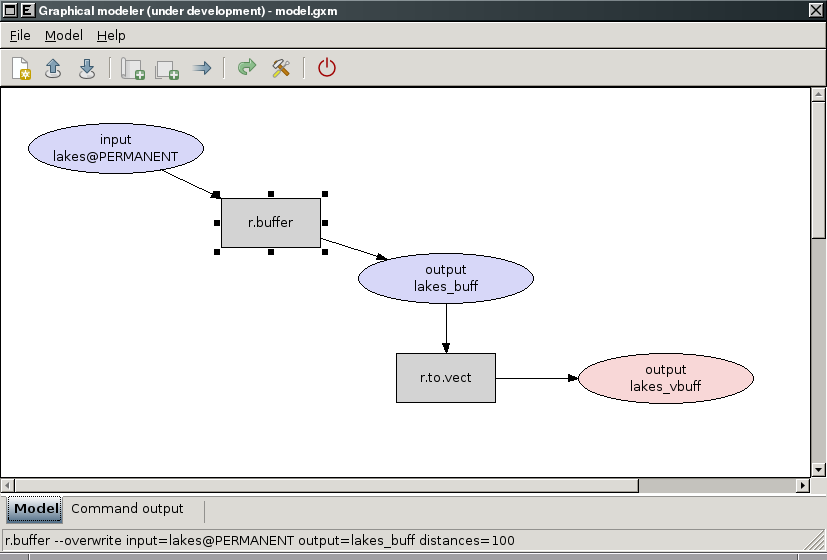
Experimental prototype of Graphical Modeler
-
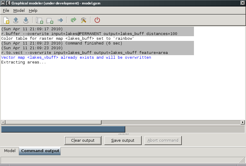
Experimental prototype of Graphical Modeler
-
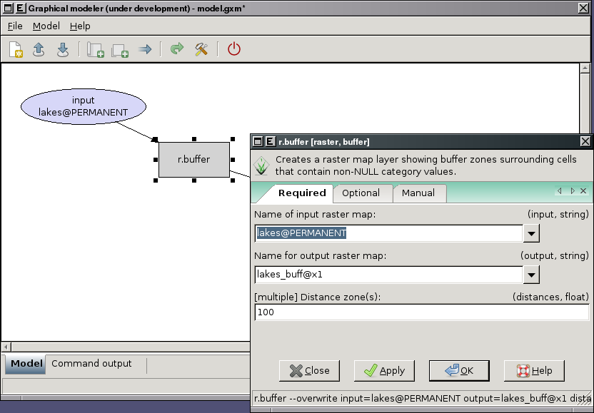
Experimental prototype of Graphical Modeler
-
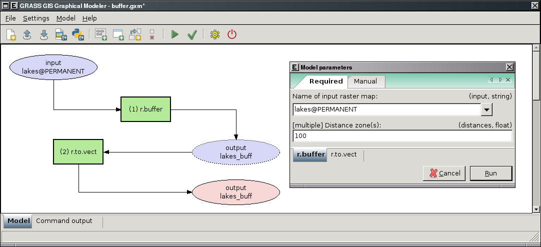
Graphical Modeler: run parametrized model
-
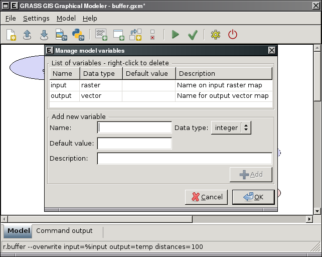
Graphical Modeler: define model variables
-
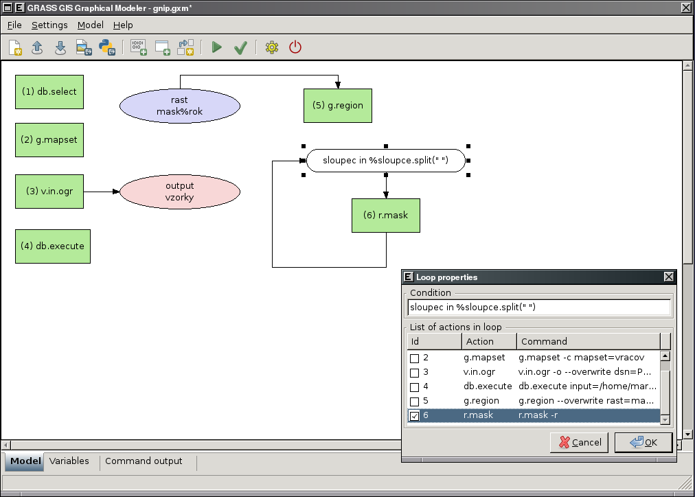
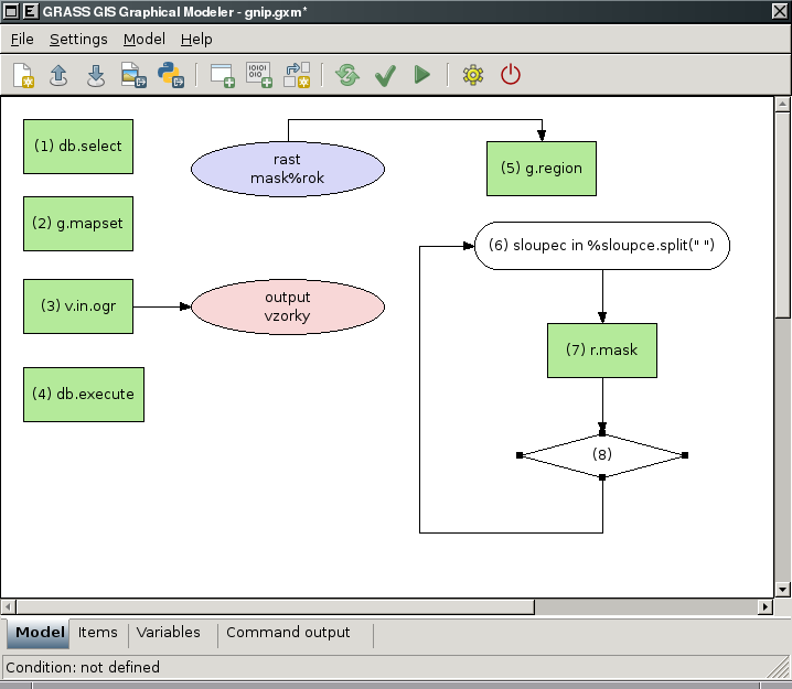
Graphical Modeler: define loops in the model
-
Graphical Modeler: define if/else statements in the model
-
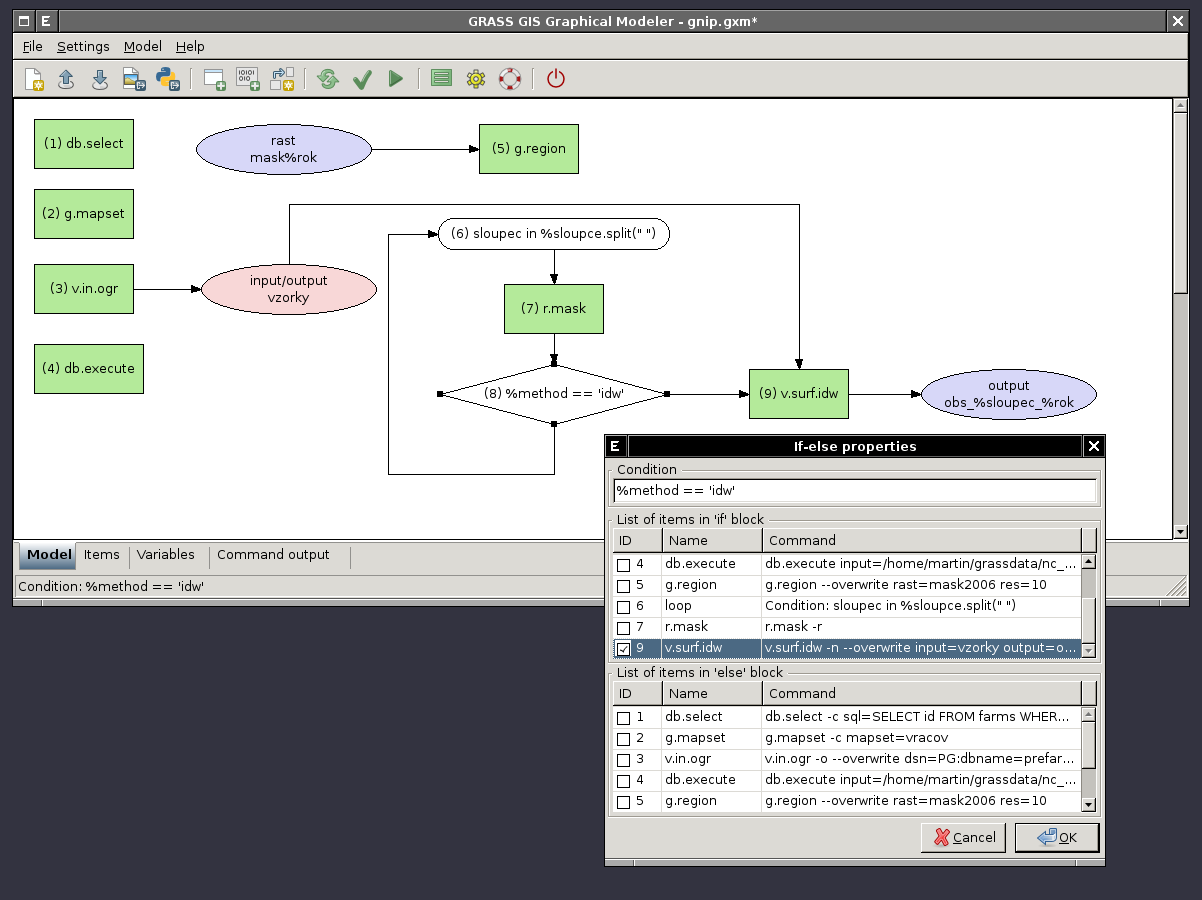
Graphical Modeler: define if/else statements in the model - show properties
-
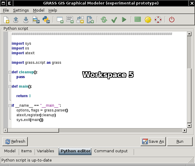
Graphical Modeler: Python editor


Video tutorials
1) create schema with name of input mapset
2) copy vector maps from selected mapset to the current and stores their attributes in SQLite database
3) exports GRASS vector maps to the selected PostGIS database
External links
Graphical modeller in action:
- Brief description GRASS Graphical Modeler (in Russian)
Other products:
Acknowledgement
wxGUI Graphical Modeler was developed by Martin Landa with institutional support of the Czech Technical University in Prague