GRASS 6 Terminology
Jump to navigation
Jump to search
General
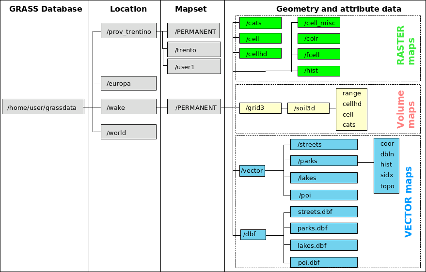
- DATABASE: This is the unix directory containing the geographic LOCATIONS (also called GISDBASE). For a desktop GIS user typically this will be a subdirectory called grassdata in your home directory.
- LOCATION: This is the name of an available geographic location. It contains a series of MAPSETS which share a common map projection.
- Typically its name will be based on the larger job/project you are working on, a reflection of the map projection which it will use, or a combination of both of these. For example: "The_Rockies", "UTM18_nad27", "LL_wgs84", "Spearfish60", "simple_xy".
- MAPSET: Every GRASS session runs under the name of a MAPSET. A MAPSET may be a geographical subset or as large as the parent LOCATION. Technically they are subdirectories under any location. In a networked environment with several users working within the same location, mapsets play a special role. Users may only select (and thus modify) a mapset that they own (i.e., have created). However, data in all mapsets for a given location can be read by anyone (unless prevented by UNIX file permissions). The "PERMANENT" mapset usually contains the read-only base maps like the elevation model, while the other locations are readable and writable by their owners. The "PERMANENT" mapset also contains some information about the location itself that is not found in the mapsets (projection info etc.), thus it must exist in every location.
- The MAPSETS might be named for their owner (on a networked multi-user system) (e.g. user1), a specific area or study site within the greater region (e.g. Wade_County), all maps concerning a specific field study (e.g. Jan2008), or whatever is useful to organize your data.

- REGION: The REGION may be the entire area or subset of the chosen LOCATION. It is defined by northern, southern, eastern, and western bounds, as well as the raster grid resolution. It is controlled by the g.region module and is of primary importance for raster operations. Its most obvious effect is of setting the map zoom, but it is much more than that.
- WINDOW: see REGION
Raster map precision
- CELL DATA TYPE: a raster map from INTEGER type (whole numbers only)
- FCELL DATA TYPE: a raster map from FLOAT type (4 bytes, 7-9 digits precision)
- DCELL DATA TYPE: a raster map from DOUBLE type (8 bytes, 15-17 digits precision)
- NULL: represents "no data" in raster maps, to be distinguished from 0 (zero) data value
- INTEGER MAP: see CELL DATA TYPE
- FLOAT MAP: see FCELL DATA TYPE
- DOUBLE MAP: see DCELL DATA TYPE
Raster 3D maps
- VOXEL: Volumetric Pixel -- a 3-dimensional grid cell. (An individual cube in a greater 3D region block)
Vector maps
- CATEGORY NUMBER: A numerical value for a map feature (e.g. road number). The CATEGORY NUMBER is related to the attribute database. The internal vector feature ID is different from this.
- LAYER: A single vector map can be connected to multiple database tables. This number determines which table to use.
- DRIVER: The database backend. e.g. dbf, sqlite, pg, mysql
- TABLE: The attribute table(s) associated with a map.
- DATABASE: The path or connection to the backend database storage.
- KEY COLUMN: The attribute column that relates the spatial data to the attribute database data. Typically the cat column is used as the key column.
- SQL: The Structured Query Language. A standardized method of accessing and manipulating databases. Almost all modern databases speak some dialect of this common language.
Map Projections
See the GIS Concepts wiki page for details.
see the GRASS 7 Terminology page for more discussion.