WxGUI Cartographic Composer: Difference between revisions
mNo edit summary |
mNo edit summary |
||
| (77 intermediate revisions by 4 users not shown) | |||
| Line 1: | Line 1: | ||
{{ | ''For development issues see'' '''[http://trac.osgeo.org/grass/wiki/wxGUIDevelopment/GUIForPs.map Trac page]'''. | ||
__TOC__ | |||
The '''Cartographic Composer''' (so called ''wx.psmap'') is a GUI application which allows GRASS users to prepare interactively hardcopy map outputs. The application can write a instructions file for GRASS module {{cmd|ps.map}}, and then run this module on the background to create PostScript output directly. See the [http://lists.osgeo.org/pipermail/grass-user/2011-March/060158.html announcement] in the mailing list. See also the {{cmd|wxGUI.psmap|desc=manual}}. | |||
Cartographic Composer is release under [https://svn.osgeo.org/grass/grass/trunk/GPL.TXT GNU GPL] licence and the source is available from [https://svn.osgeo.org/grass/grass/trunk/gui/wxpython/psmap GRASS SVN repository]. The composer is part of core GRASS GIS. To run the composer, it is necessary to have the [http://pythonware.com/products/pil Python Imaging Library] (on some systems called "python-pillow" package) installed. | |||
''Note:'' {{cmd|ps.map}} (see also {{AddonCmd|ps.output}}) is a GRASS module, intended to be a stand-alone hardcopy plot generator. It is not meant to be a ''Print'' button for the maps currently displayed in the map canvas, that will need it own controls. | |||
The Cartographic Composer is '''available in [http://grass.osgeo.org/download/software/#g64x GRASS 6.4.2+]''' from the Layer manager menu <code>File → Cartographic Composer</code> or from the toolbar [[Image:print-compose.png]]. | |||
In [http://grass.osgeo.org/grass7/ GRASS 7] the tool is also available from the command line as stand-alone application ({{cmd|g.gui.psmap}}). | |||
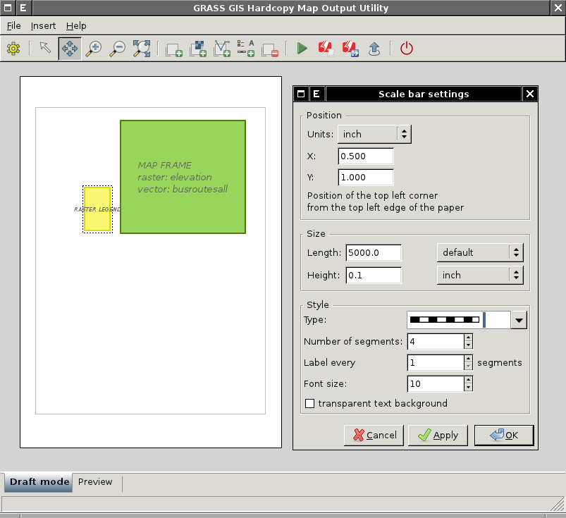
[[Image:wxpsmap-draft.png|center|thumb|480px|Cartographic Composer - draft mode]] | |||
== Supported mapping instructions == | |||
The GUI ( | The GUI currently supports the most important mapping instructions (see also {{cmd|ps.map}} manual page): | ||
* paper | * paper | ||
* scale | * scale | ||
| Line 15: | Line 23: | ||
* rast | * rast | ||
* vects | * vects | ||
* scalebar | * scalebar | ||
* mapinfo | * mapinfo | ||
* legend | |||
* text labels | * text labels | ||
* eps (image, north arrow) | |||
<center><gallery widths=300px heights=300px> | |||
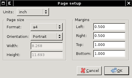
Image:wxpsmap-page-setup.png|Cartographic Composer - page setup dialog | |||
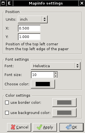
Image:wxpsmap-mapinfo.png|Cartographic Composer - mapinfo dialog | |||
</gallery></center> | |||
<!--== Installation == | |||
After installation launch ''Cartographic Composer'' from wxGUI menu | |||
File -> Cartographic Composer | |||
=== Requirements === | |||
* '''GRASS 6.4.2+''' is required. On MS Windows you can try [http://wingrass.fsv.cvut.cz daily builds] which already comes {{addonCmd|wx.psmap}} installed. | |||
* ''(optional)'' [http://www.pythonware.com/products/pil/ Python Imaging Library] for preview functionality | |||
* ''(optional)'' [http://www.ps2pdf.com ps2pdf] for PDF export | |||
=== From wxGUI === | === From wxGUI === | ||
| Line 32: | Line 50: | ||
Setting -> Install extension from add-ons | Setting -> Install extension from add-ons | ||
# Click on "Fetch" button | |||
# Choose "wxGUI | wx.psmap" | |||
# Check in "Install system-wide (may need system administrator rights)" | |||
# And install selected extension by clicking on "Install" | |||
[[Image:wxgui-install-extension.png|center|480px|thumb|Installing wx.psmap from wxGUI]] | [[Image:wxgui-install-extension.png|center|480px|thumb|Installing wx.psmap from wxGUI]] | ||
| Line 40: | Line 59: | ||
=== From Command Prompt === | === From Command Prompt === | ||
In GRASS 7: | ;In GRASS 7: | ||
g.extension -s svnurl=https://svn.osgeo.org/grass/grass-addons extension=wx.psmap | g.extension -s svnurl=https://svn.osgeo.org/grass/grass-addons extension=wx.psmap | ||
In GRASS 6: | ;In GRASS 6: | ||
''Note'': {{cmd|g.extension|version= | ''Note'': {{cmd|g.extension|version=64}} in GRASS 6 doesn't support installing wxGUI extensions. You can install {{addonCmd|wx.psmap}} from ''wxGUI Command prompt'' using Python version of {{cmd|g.extension}} available as ''g.extension.py'' | ||
g.extension.py -s svnurl=https://svn.osgeo.org/grass/grass-addons extension=wx.psmap | g.extension.py -s svnurl=https://svn.osgeo.org/grass/grass-addons extension=wx.psmap | ||
[[Image:wxGUI-install-addons-cmd.png|center|480px|thumb|Installing wx.psmap from wxGUI Command Prompt]] | [[Image:wxGUI-install-addons-cmd.png|center|480px|thumb|Installing wx.psmap from wxGUI Command Prompt]]--> | ||
== Video tutorials == | |||
{{YouTube|ZMwuC14omyA}} | |||
{{YouTube|s0gYrGuzzpo}} | |||
{{YouTube|XKXtwoMh6Kk|desc=How to add north arrow}} | |||
{{YouTube|8o5cRyH3hb8|desc=Raster, legend, vector outline}} | |||
== Input == | == Input == | ||
* Ability to load in saved ps.map | * Ability to load in saved {{cmd|ps.map}} instructions file. I consider this to be a low priority, deal with it after map creation is fully functional. Start with scripts saved using the GUI, after that is working expand to load any ps.map instructions file. | ||
== Outputs == | == Outputs == | ||
* ps.map instructions file | * {{cmd|ps.map}} instructions file | ||
* PostScript file | * PostScript file | ||
* PDF | * PDF file | ||
{{wxGUI}} | {{wxGUI}} | ||
== Map Output Examples == | |||
[[Category: ps.map]] | |||
<center><gallery widths=300px heights=300px> | |||
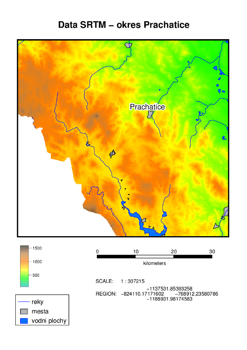
Image:DEM SRTM.png| data source: [http://grass.fsv.cvut.cz/gwiki/FreeGeodataCZ FreeGeodataCZ] | |||
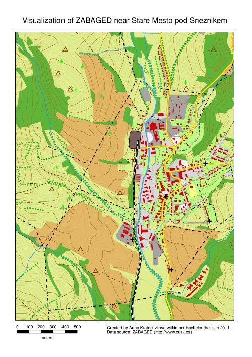
Image:StareMesto.png| data source: ZABAGED (http://www.cuzk.cz) | |||
</gallery></center> | |||
Examples were created within A. Kratochvilova's [http://geo.fsv.cvut.cz/proj/bp/2011/anna-kratochvilova-bp-2011.pdf bachelor thesis] (in Czech) | |||
== Acknowledgement == | |||
wxGUI Cartographic Composer was developed within a bachelor thesis at the [http://www.cvut.cz Czech Technical University in Prague] by Anna Kratochvilova in 2011. | |||
Latest revision as of 21:51, 15 December 2015
For development issues see Trac page.
The Cartographic Composer (so called wx.psmap) is a GUI application which allows GRASS users to prepare interactively hardcopy map outputs. The application can write a instructions file for GRASS module ps.map, and then run this module on the background to create PostScript output directly. See the announcement in the mailing list. See also the manual.
Cartographic Composer is release under GNU GPL licence and the source is available from GRASS SVN repository. The composer is part of core GRASS GIS. To run the composer, it is necessary to have the Python Imaging Library (on some systems called "python-pillow" package) installed.
Note: ps.map (see also ps.output) is a GRASS module, intended to be a stand-alone hardcopy plot generator. It is not meant to be a Print button for the maps currently displayed in the map canvas, that will need it own controls.
The Cartographic Composer is available in GRASS 6.4.2+ from the Layer manager menu File → Cartographic Composer or from the toolbar ![]() .
.
In GRASS 7 the tool is also available from the command line as stand-alone application (g.gui.psmap).
Supported mapping instructions
The GUI currently supports the most important mapping instructions (see also ps.map manual page):
- paper
- scale
- maploc
- rast
- vects
- scalebar
- mapinfo
- legend
- text labels
- eps (image, north arrow)
-
Cartographic Composer - page setup dialog
-
Cartographic Composer - mapinfo dialog
Video tutorials
Input
- Ability to load in saved ps.map instructions file. I consider this to be a low priority, deal with it after map creation is fully functional. Start with scripts saved using the GUI, after that is working expand to load any ps.map instructions file.
Outputs
- ps.map instructions file
- PostScript file
- PDF file
Map Output Examples
-
data source: FreeGeodataCZ
-
data source: ZABAGED (http://www.cuzk.cz)
Examples were created within A. Kratochvilova's bachelor thesis (in Czech)
Acknowledgement
wxGUI Cartographic Composer was developed within a bachelor thesis at the Czech Technical University in Prague by Anna Kratochvilova in 2011.
