Vector network analysis/pl: Difference between revisions
mNo edit summary |
mNo edit summary |
||
| (One intermediate revision by one other user not shown) | |||
| Line 1: | Line 1: | ||
GRASS | Narzędzia GRASS do analiz sieciowych bazują na bibliotece [http://trac.osgeo.org/grass/browser/grass/trunk/lib/vector/dglib/ DGlib] Directed Graph Library. | ||
GRASS 7 has [[WxGUI Vector Network Analysis Tool]] front-end, which supports some of the vector network analysis modules. | |||
__TOC__ | |||
== Zaimplementowane algorytmy == | == Zaimplementowane algorytmy == | ||
| Line 7: | Line 10: | ||
Poniższe algorytmy są zaimplementowane (w GRASS 6.5+): | Poniższe algorytmy są zaimplementowane (w GRASS 6.5+): | ||
* Utrzymanie sieci: {{cmd|v.net | * Utrzymanie sieci: {{cmd|v.net}} | ||
* Najkrótsza trasa: {{cmd|d.path|version=64}} and {{cmd|v.net.path | * Najkrótsza trasa: {{cmd|d.path|version=64}} and {{cmd|v.net.path}} | ||
* Najkrótsza trasa pomiędzy wszystkimi parami punktów: {{cmd|v.net.allpairs | * Najkrótsza trasa pomiędzy wszystkimi parami punktów: {{cmd|v.net.allpairs}} | ||
* Wyznaczanie podsieci (tworzenie podsieci, np. police station zones): {{cmd|v.net.alloc | * Wyznaczanie podsieci (tworzenie podsieci, np. police station zones): {{cmd|v.net.alloc}} | ||
* Strefy jednakowych odległości (ze środków): {{cmd|v.net.iso | * Strefy jednakowych odległości (ze środków): {{cmd|v.net.iso}} | ||
* Obliczanie mostów i punktów artykulacji: {{cmd|v.net.bridge | * Obliczanie mostów i punktów artykulacji: {{cmd|v.net.bridge}} | ||
* Computes degree, centrality, betweeness, closeness and eigenvector centrality measures: {{cmd|v.net.centrality | * Computes degree, centrality, betweeness, closeness and eigenvector centrality measures: {{cmd|v.net.centrality}} | ||
* Obliczanie dobrze i słabo połączonych komponentów: {{cmd|v.net.components | * Obliczanie dobrze i słabo połączonych komponentów: {{cmd|v.net.components}} | ||
* Obliczanie stopnia połączenia pomiędzy dwoma zestawami punktów: {{cmd|v.net.connectivity | * Obliczanie stopnia połączenia pomiędzy dwoma zestawami punktów: {{cmd|v.net.connectivity}} | ||
* Obliczanie najkrótszej drogi w sieci pomiędzy zadanymi zestawami obiektów: {{cmd|v.net.distance | * Obliczanie najkrótszej drogi w sieci pomiędzy zadanymi zestawami obiektów: {{cmd|v.net.distance}} | ||
* Obliczanie maksymalnego przepływu pomiędzy dwoma zestawami punktów: {{cmd|v.net.flow | * Obliczanie maksymalnego przepływu pomiędzy dwoma zestawami punktów: {{cmd|v.net.flow}} | ||
* Obliczanie minimalnego drzewa rozpinającego: {{cmd|v.net.spanningtree | * Obliczanie minimalnego drzewa rozpinającego: {{cmd|v.net.spanningtree}} | ||
* Minimalne drzewa Steinera (star-like connections, e.g. broadband cable connections): {{cmd|v.net.steiner | * Minimalne drzewa Steinera (star-like connections, e.g. broadband cable connections): {{cmd|v.net.steiner}} | ||
* Znajdowanie najkrótszej drogi z użyciem rozkładów jazdy: {{cmd|v.net.timetable | * Znajdowanie najkrótszej drogi z użyciem rozkładów jazdy: {{cmd|v.net.timetable}} | ||
* Analizy komiwojażera (round trip): {{cmd|v.net.salesman | * Analizy komiwojażera (round trip): {{cmd|v.net.salesman}} | ||
Vector directions are defined by the digitizing direction (a-->--b). You can navigate either omnidirectionally or differently in each directions as both directions are supported. Network modules provide parameters to assign attribute columns to the forward and backward direction. To see how a vector is directed, use the "display" parameter of {{cmd|d.vect}} (set display=dir). | Vector directions are defined by the digitizing direction (a-->--b). You can navigate either omnidirectionally or differently in each directions as both directions are supported. Network modules provide parameters to assign attribute columns to the forward and backward direction. To see how a vector is directed, use the "display" parameter of {{cmd|d.vect}} (set display=dir). | ||
Use [[Turntable]] to assign costs to turns on the network. | |||
* | * strona pomocy {{cmd|vectorintro}} "vector map processing and network analysis" | ||
== | == Przykład: Najkrótsza droga == | ||
* zobacz strony opisujące {{cmd|v.net.path}} i {{cmd|d.path}} | * zobacz strony opisujące {{cmd|v.net.path}} i {{cmd|d.path}} | ||
== Najważniejsze parametry == | |||
* '''input''' - This is the name of input vector map or data source for direct OGR access. | |||
* '''output''' - This is the name for output vector map. | |||
* '''type''' - This parameter defines arc type, which can be line or boundary. | |||
* '''alayer''' - This parameter is a number and defines the arc layer. Vector features can have category values in different layers. This number determines which layer to use. When used with direct OGR access this is the layer name. | |||
* '''nlayer''' - This parameter is a number and defines the node layer. Vector features can have category values in different layers. This number determines which layer to use. When used with direct OGR access this is the layer name. | |||
* '''afcolumn''' - This is name of the cost column for moving in forward direction or forward and backward directions together. | |||
* '''abcolumn''' - This is name of the cost column for moving in backward direction. | |||
* '''ncolumn''' - This is name of the cost column for moving through nodes. | |||
If you are not familiar with layers concept in GRASS see [[Vector Database Management]]. | |||
== Nowe pomysły == | == Nowe pomysły == | ||
| Line 35: | Line 59: | ||
* [[Vector network analysis ideas]] (pomóż w realizacji) | * [[Vector network analysis ideas]] (pomóż w realizacji) | ||
== Zrzuty ekranu == | === Zrzuty ekranu z GRASS GIS 7 === | ||
[[Image:Grass7_vector_network_tool_salesman.png|center|600px|thumb|Travelling salesman ({{cmd|v.net.salesman}})]] | |||
[[Image: | [[Image:Grass7_vector_network_tool_alloc.png|center|600px|thumb|Subsets for nearest centers ({{cmd|v.net.alloc}})]] | ||
[[Image:wxgui-vnet-alloc.png|center|600px|thumb|Subsets for nearest centers ({{cmd|v.net.alloc}})]] | |||
[[ | Zobacz też | ||
* [[WxGUI Vector Network Analysis Tool]] | |||
* więcej zrzutów ekranu [https://grass.osgeo.org/screenshots/vector/ ze strony GRASS] | |||
=== Zrzuty ekranu ze starszej wersji GRASS 5 === | |||
[[Image:D.path.jpg|center| | <center> | ||
{| | |||
| [[Image:V.net.iso.png|center|400px|thumb|{{cmd|v.net.iso}} - Split net to bands between cost isolines (direction from centre). Costs of centre node are used in calculation.]] | |||
|[[Image:V.net.alloc.png|center|400px|thumb|{{cmd|v.net.alloc}} - Allocates subnets for nearest centres (direction from centre). Costs of centre node are used in calculation.]] | |||
|- | |||
|[[Image:D.path.jpg|center|400px|thumb|{{cmd|d.path}} - Znajduje najkrótszą drogę dla wybranych początkowych i końcowych punktów.]] | |||
| | |||
|} | |||
</center> | |||
== See also == | == See also == | ||
* [[GSoC Network Analysis]]: | * [[Turntable]] | ||
* [[GSoC Network Analysis]]: wiele nowych modułów! | |||
== Linki zewnętrzne == | == Linki zewnętrzne == | ||
Latest revision as of 10:00, 4 December 2018
Narzędzia GRASS do analiz sieciowych bazują na bibliotece DGlib Directed Graph Library.
GRASS 7 has WxGUI Vector Network Analysis Tool front-end, which supports some of the vector network analysis modules.
Zaimplementowane algorytmy
Poniższe algorytmy są zaimplementowane (w GRASS 6.5+):
- Utrzymanie sieci: v.net
- Najkrótsza trasa: d.path and v.net.path
- Najkrótsza trasa pomiędzy wszystkimi parami punktów: v.net.allpairs
- Wyznaczanie podsieci (tworzenie podsieci, np. police station zones): v.net.alloc
- Strefy jednakowych odległości (ze środków): v.net.iso
- Obliczanie mostów i punktów artykulacji: v.net.bridge
- Computes degree, centrality, betweeness, closeness and eigenvector centrality measures: v.net.centrality
- Obliczanie dobrze i słabo połączonych komponentów: v.net.components
- Obliczanie stopnia połączenia pomiędzy dwoma zestawami punktów: v.net.connectivity
- Obliczanie najkrótszej drogi w sieci pomiędzy zadanymi zestawami obiektów: v.net.distance
- Obliczanie maksymalnego przepływu pomiędzy dwoma zestawami punktów: v.net.flow
- Obliczanie minimalnego drzewa rozpinającego: v.net.spanningtree
- Minimalne drzewa Steinera (star-like connections, e.g. broadband cable connections): v.net.steiner
- Znajdowanie najkrótszej drogi z użyciem rozkładów jazdy: v.net.timetable
- Analizy komiwojażera (round trip): v.net.salesman
Vector directions are defined by the digitizing direction (a-->--b). You can navigate either omnidirectionally or differently in each directions as both directions are supported. Network modules provide parameters to assign attribute columns to the forward and backward direction. To see how a vector is directed, use the "display" parameter of d.vect (set display=dir). Use Turntable to assign costs to turns on the network.
- strona pomocy vectorintro "vector map processing and network analysis"
Przykład: Najkrótsza droga
- zobacz strony opisujące v.net.path i d.path
Najważniejsze parametry
- input - This is the name of input vector map or data source for direct OGR access.
- output - This is the name for output vector map.
- type - This parameter defines arc type, which can be line or boundary.
- alayer - This parameter is a number and defines the arc layer. Vector features can have category values in different layers. This number determines which layer to use. When used with direct OGR access this is the layer name.
- nlayer - This parameter is a number and defines the node layer. Vector features can have category values in different layers. This number determines which layer to use. When used with direct OGR access this is the layer name.
- afcolumn - This is name of the cost column for moving in forward direction or forward and backward directions together.
- abcolumn - This is name of the cost column for moving in backward direction.
- ncolumn - This is name of the cost column for moving through nodes.
If you are not familiar with layers concept in GRASS see Vector Database Management.
Nowe pomysły
- Vector network analysis ideas (pomóż w realizacji)
Zrzuty ekranu z GRASS GIS 7
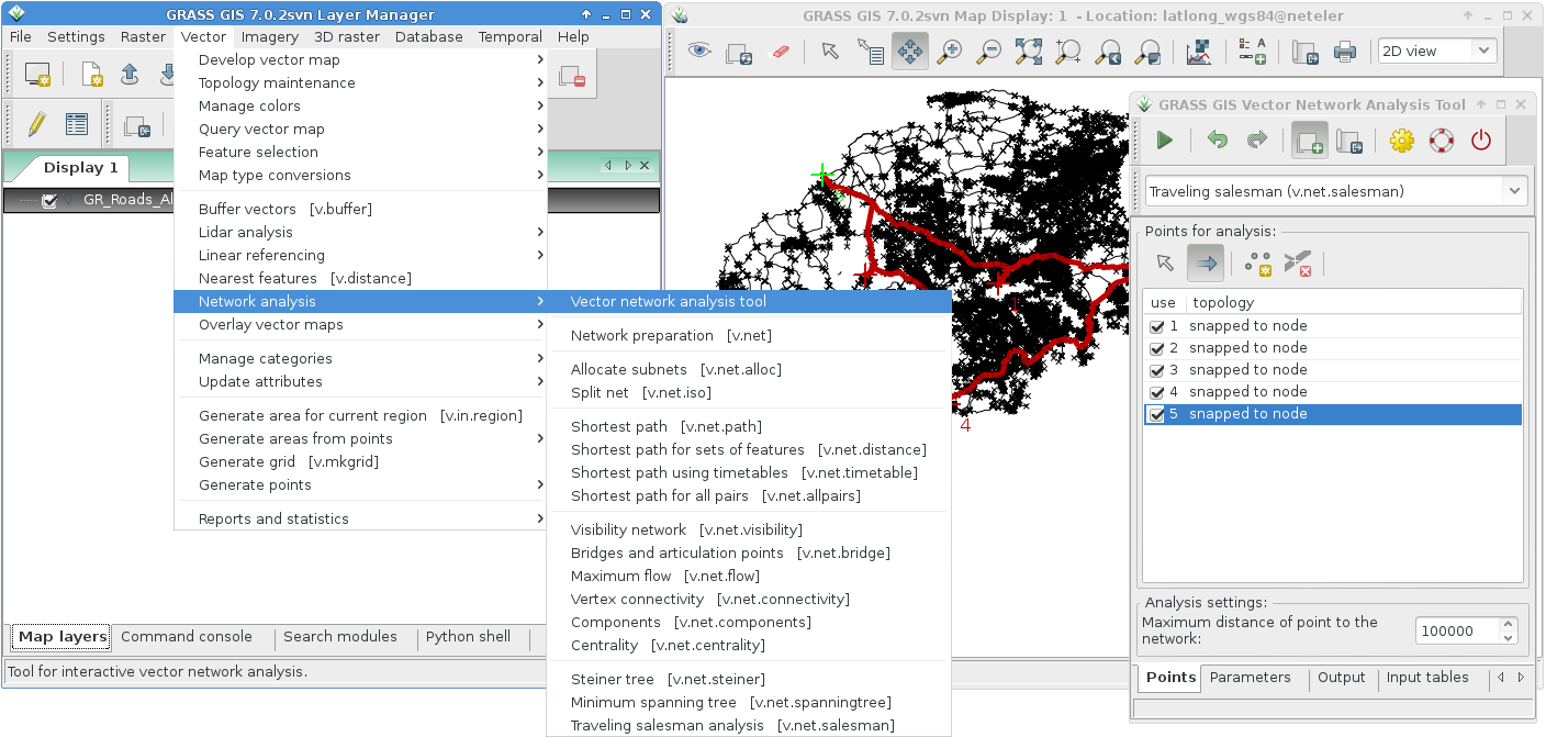
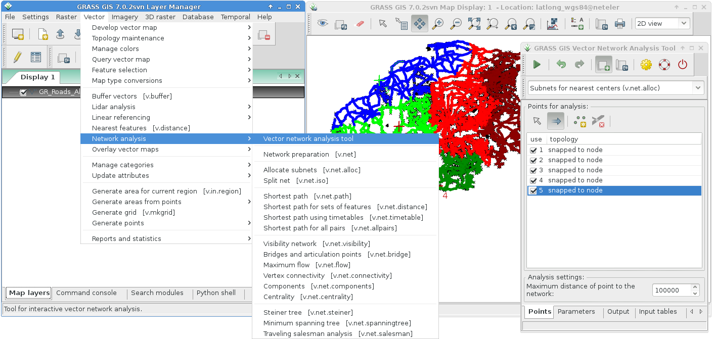
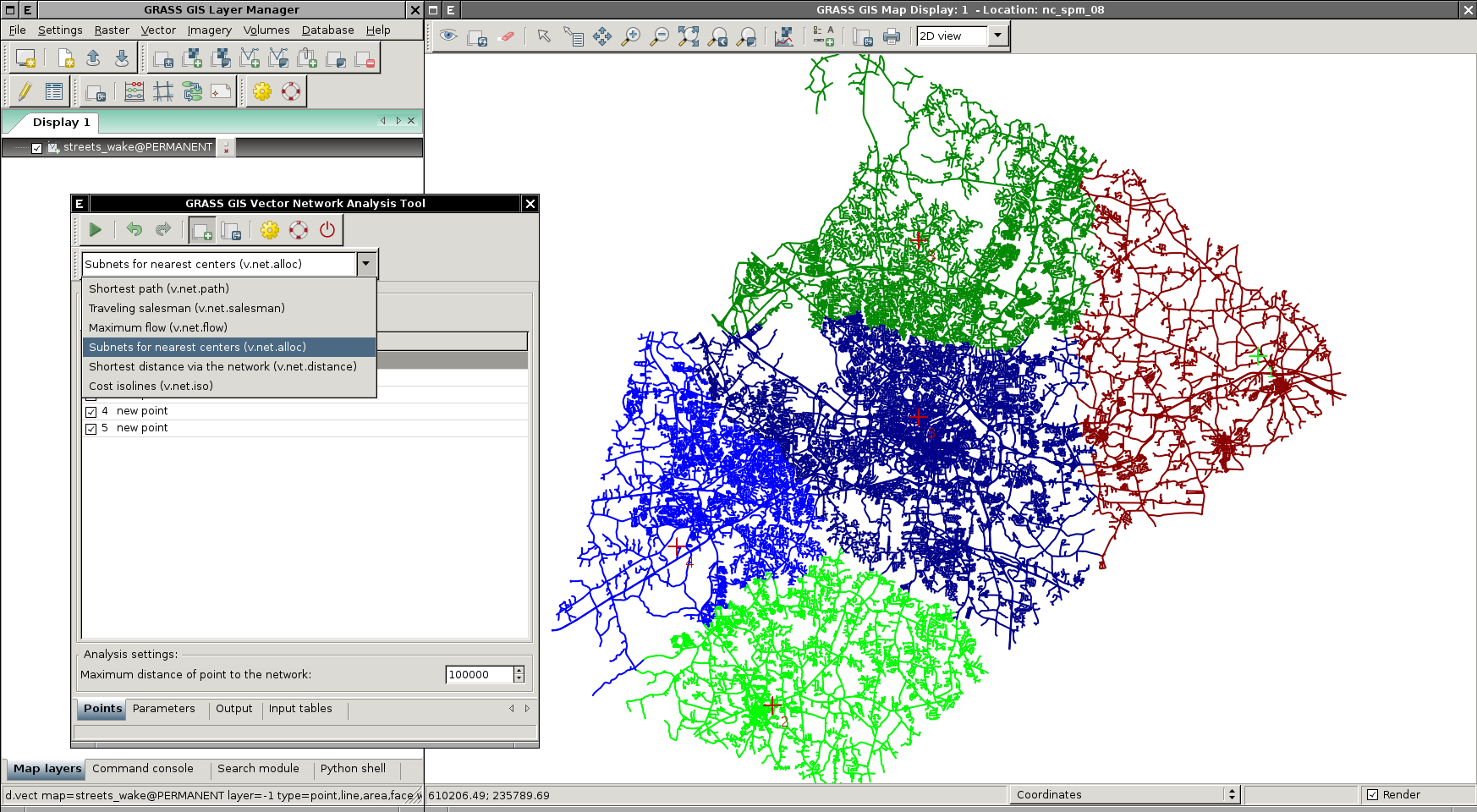
Zobacz też
- WxGUI Vector Network Analysis Tool
- więcej zrzutów ekranu ze strony GRASS
Zrzuty ekranu ze starszej wersji GRASS 5
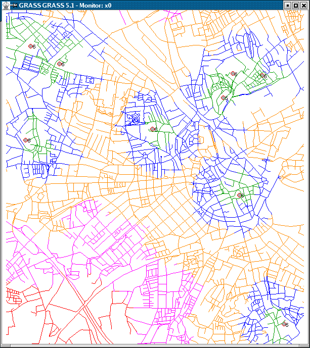 |
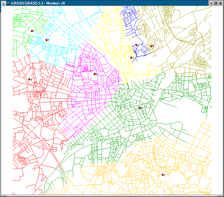 |
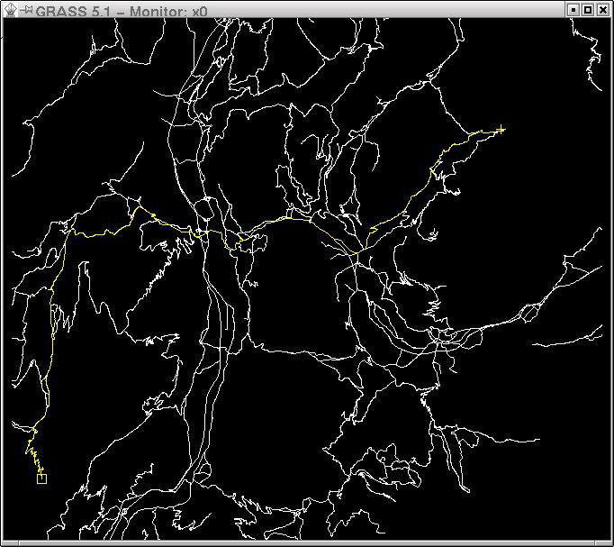 |
See also
- Turntable
- GSoC Network Analysis: wiele nowych modułów!