OpenStreetMap: Difference between revisions
(+Download as own section) |
|||
| (6 intermediate revisions by 3 users not shown) | |||
| Line 4: | Line 4: | ||
== | == Download == | ||
==== Administrative boundaries from OpenStreetMap ==== | |||
For a convenient download in GeoJSON and SHAPE, see https://wambachers-osm.website/boundaries/ | |||
(using the almost invisible triangle, you can pop out details of a country down to admin level 8) | |||
=== Data as shapefiles === | === Data as shapefiles === | ||
Get data from here: | Get data from here: | ||
* http://download.geofabrik.de/osm/ ,or | * http://download.geofabrik.de/osm/ , or | ||
* http://downloads.cloudmade.com/ | * http://downloads.cloudmade.com/ | ||
=== Data from WMS === | |||
* Web Map Service (WMS) for Europe: [http://mapbender.wheregroup.com/cgi-bin/mapserv?map=/data/umn/osm/osm_basic.map&VERSION=1.1.1&REQUEST=GetCapabilities&SERVICE=WMS GetCapabilities] to access the WMS | |||
* Free/open world-wide server: http://www.mundialis.de/ows-mundialis/ | |||
=== Data as OSM pbf === | |||
Get data from here: | |||
* http://download.geofabrik.de/osm/ | |||
== Import == | |||
* [[GRASS_AddOns#v.in.osm]] (fairly rough script) | |||
Conversion with {{wikipedia|Mapnik}} to raster tiles may work, but be very careful about projection issues, typically online web map tiles are not appropriate for GIS import. | |||
=== Data as shapefiles === | |||
Import with {{cmd|v.in.ogr}}. | |||
=== Data from WMS === | === Data from WMS === | ||
Import with {{cmd|r.in.wms}}. | |||
=== Data as OSM pbf === | |||
Read http://gdal.org/drv_osm.html. Create a OSM_CONFIG_FILE file, selecting tags. The options other_tags and all_tags should be disabled to avoid errors when creating attribute tables. | |||
When importing, use the layer and where options of {{cmd|v.in.ogr}} in order to import only the required features and in order to avoid topological problems. | |||
For example, import roads from some pbf file with | |||
v.in.ogr layer=lines where="highway <> ' '". | |||
Import landuse from some pbf file with | |||
v.in.ogr layer=multipolygons where="landuse <> ' '" | |||
Import landuse from some pbf file with | |||
v.in.ogr layer=multipolygons where="landuse <> ' '" | |||
Import administrative boundaries for a particular level with | |||
v.in.ogr layer=multipolygons where="boundary = 'administrative' and admin_level = '<desired level'" | |||
'''Alternative''': use {{AddonCmd|v.in.osm}}. | |||
=OSM vs. GRASS topology= | =OSM vs. GRASS topology= | ||
| Line 29: | Line 66: | ||
OSM topological model is different to GRASS topological model. OSM topologically correct connections of the lines can be on all nodes of the line. Unlike OSM, GRASS allows to connect lines only on their starting/end nodes.Therefore after the import it is needed to split lines into the smallest segments by "v.split vertices=2". However after application of the v.split, there are too many lines and some of them are not necessary. Module {{cmd|version=71|v.build.polylines}} cats=same merges the extra lines into single polyline. | OSM topological model is different to GRASS topological model. OSM topologically correct connections of the lines can be on all nodes of the line. Unlike OSM, GRASS allows to connect lines only on their starting/end nodes.Therefore after the import it is needed to split lines into the smallest segments by "v.split vertices=2". However after application of the v.split, there are too many lines and some of them are not necessary. Module {{cmd|version=71|v.build.polylines}} cats=same merges the extra lines into single polyline. | ||
Correct topological model is necessary e.g. to perform [[Vector network analysis]]. | |||
== | ==Example== | ||
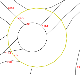
The following image represents roundabout after the import of the OSM shapefile from geofabrik. You can see that there is only one category number 917 | The following image represents roundabout after the import of the OSM shapefile from geofabrik. You can see that there is only one category number 917. It means that the roundabout circle is just one line and grass does not see all connections to the other lines, because they are not on the starting/end node of the circle. | ||
[[Image:01 roundabout before.png|center|700px|thumb|v.in.ogr output]] | [[Image:01 roundabout before.png|center|700px|thumb|v.in.ogr output]] | ||
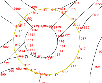
After the application of v.split | After the application of v.split it gives too many one segment lines. It is clear form the following image: | ||
[[Image:02 roundabout split.png|center|700px|thumb|v.split output]] | [[Image:02 roundabout split.png|center|700px|thumb|v.split output]] | ||
{{cmd|version=71|v.build.polylines}} | {{cmd|version=71|v.build.polylines}} merges unnecessary segments. All lines starts/ends on the intersections with other lines as can be seen on the following image: | ||
[[Image:03 roundabout after.png|center|700px|thumb|v.build.polylines output]] | [[Image:03 roundabout after.png|center|700px|thumb|v.build.polylines output]] | ||
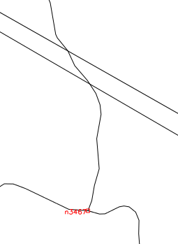
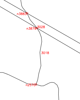
There is another possibility | There is another possibility to use {{cmd|version=71|v.clean}} <tt>tool=break</tt> but if there is e.g. a bridge then v.clean connects it to the roads going below it which is incorrect. The above described approach does not split the bridge there. See the difference on the following images: | ||
[[Image:Vclean difference.png|center|700px|thumb|Output of v.split -> v.build.polylines]] | [[Image:Vclean difference.png|center|700px|thumb|Output of v.split -> v.build.polylines]] | ||
Latest revision as of 16:24, 10 May 2018
OSM Homepage: http://www.openstreetmap.org/
Download
Administrative boundaries from OpenStreetMap
For a convenient download in GeoJSON and SHAPE, see https://wambachers-osm.website/boundaries/
(using the almost invisible triangle, you can pop out details of a country down to admin level 8)
Data as shapefiles
Get data from here:
Data from WMS
- Web Map Service (WMS) for Europe: GetCapabilities to access the WMS
- Free/open world-wide server: http://www.mundialis.de/ows-mundialis/
Data as OSM pbf
Get data from here:
Import
- GRASS_AddOns#v.in.osm (fairly rough script)
Conversion with Mapnik to raster tiles may work, but be very careful about projection issues, typically online web map tiles are not appropriate for GIS import.
Data as shapefiles
Import with v.in.ogr.
Data from WMS
Import with r.in.wms.
Data as OSM pbf
Read http://gdal.org/drv_osm.html. Create a OSM_CONFIG_FILE file, selecting tags. The options other_tags and all_tags should be disabled to avoid errors when creating attribute tables.
When importing, use the layer and where options of v.in.ogr in order to import only the required features and in order to avoid topological problems.
For example, import roads from some pbf file with
v.in.ogr layer=lines where="highway <> ' '".
Import landuse from some pbf file with
v.in.ogr layer=multipolygons where="landuse <> ' '"
Import landuse from some pbf file with
v.in.ogr layer=multipolygons where="landuse <> ' '"
Import administrative boundaries for a particular level with
v.in.ogr layer=multipolygons where="boundary = 'administrative' and admin_level = '<desired level'"
Alternative: use v.in.osm.
OSM vs. GRASS topology
OSM topological model is different to GRASS topological model. OSM topologically correct connections of the lines can be on all nodes of the line. Unlike OSM, GRASS allows to connect lines only on their starting/end nodes.Therefore after the import it is needed to split lines into the smallest segments by "v.split vertices=2". However after application of the v.split, there are too many lines and some of them are not necessary. Module v.build.polylines cats=same merges the extra lines into single polyline.
Correct topological model is necessary e.g. to perform Vector network analysis.
Example
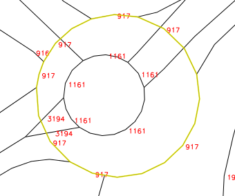
The following image represents roundabout after the import of the OSM shapefile from geofabrik. You can see that there is only one category number 917. It means that the roundabout circle is just one line and grass does not see all connections to the other lines, because they are not on the starting/end node of the circle.
After the application of v.split it gives too many one segment lines. It is clear form the following image:
v.build.polylines merges unnecessary segments. All lines starts/ends on the intersections with other lines as can be seen on the following image:
There is another possibility to use v.clean tool=break but if there is e.g. a bridge then v.clean connects it to the roads going below it which is incorrect. The above described approach does not split the bridge there. See the difference on the following images:
