PostGIS Topology: Difference between revisions
mNo edit summary |
|||
| Line 247: | Line 247: | ||
Module {{cmd|v.in.ogr|version=70}} in this case doesn't produce vector data in GRASS format, the data are directly stored in PostGIS Topology. The module also creates vector map given by <code>olink</code> parameter which points to the data stored in PostGIS database. | Module {{cmd|v.in.ogr|version=70}} in this case doesn't produce vector data in GRASS format, the data are directly stored in PostGIS Topology. The module also creates vector map given by <code>olink</code> parameter which points to the data stored in PostGIS database. | ||
v.info zone_pg | |||
... | |||
| Map format: PostGIS (PostgreSQL) | | |||
| DB table: public.zone | | |||
| DB name: pgis_db | | |||
| Geometry column: geom | | |||
| Feature type: polygon | | |||
| Topology: PostGIS (schema: topo_zone) | | |||
| Topology column: topo | | |||
=== Set output vector format to PostGIS Topology === | === Set output vector format to PostGIS Topology === | ||
Revision as of 11:25, 17 November 2013
PostGIS Topology allows to store topological vector data in PostGIS database. It's available in PostGIS 2.0 and later. GRASS GIS supports PostGIS Topology in version GRASS 7.0 and later through GRASS-PostGIS data provider.
Additional info can be found also in the presentation Working with PostGIS Topology in GRASS GIS (Seminar: Advances in GIS data processing and management at Fondazione Edmund Mach, Italy, 2013-04-13).
Background
Topological models used by GRASS GIS and PostGIS Topology are different - see below.
GRASS GIS Topology Data Model
GRASS GIS data model defines various topological elements:
- nodes - 0D elements
- For each node is defined which lines/boundaries starts and ends in this node.
- lines - 1D elements which cannot form areas
- For each line is defined a start and end node.
- boundaries - 1D elements which can form areas
- For each boundary is defined a start and end node, and an area on the left and right.
- centroids - point located inside area
- For each centroid is defined an area
- areas - 2D elements formed by closed set of boundaries and optionally by one centroid located inside the area
- For each area is defined the list of boundaries which forms the area (outer ring), and the list of isles located inside the area.
- isle - 2D elements formed by areas
- For each isle is defined the list of boundaries which forms the isle (it's outer ring), and optionally by the area where the isle is located.
For other info and examples, see GRASS GIS programmer's manual.
PostGIS Topology Model
PostGIS Topology model is based on ISO standard 13249. The model defines only three topological elements:
- nodes - 0D elements
- Defined by geometry (point) and by the face where the node is located (can be NULL)
- edges - 1D elements
- Defined by geometry (linestring), start and end node, next left and right edge (ie. connectivity) and by the face on the left and right.
- faces - 2D elements
- Defined by bounding box.
PostGIS Topology validation: see for example here
Comparison of GRASS and PostGIS Topology Data Models
| GRASS GIS | PostGIS Topology |
|---|---|
| Nodes | |
| nlines,lines,angles | containing_face, geom(Point) |
| Edge | |
| start/end node, next left/right edge, left/right face, geom (LineString) | |
| Line | |
| start/end node | |
| Boundary | |
| start/end node, left/right area | |
| Centroid | |
| area | |
| Face | |
| mbr(Polygon) | |
| Area | |
| nlines,lines,nisles,isle,centroid | |
| Isle | |
| nlines,lines,area | |
PostGIS Topology implementation in GRASS GIS
- Points are stored as isolated nodes (containing_face is null)
- Centroids are stored as isolated nodes (containing_face is not null)
- Lines are stored as edges (left_face and right_face is 0)
- Boundaries are stored edges
- Areas are stored as faces (with id > 0)
- Isles are stored as faces (with id <= 0) (including universal face defined by PostGIS Topology)
Additional topological data related to nodes, areas, and isles are stored in separated tables, see figure bellow.
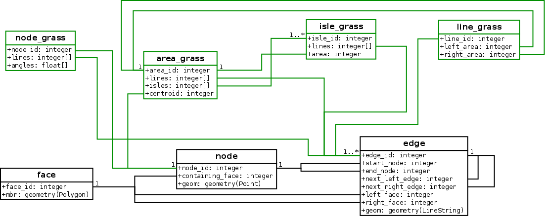
Storing GRASS-related topological data in DB can be disabled by TOPO_GEO_ONLY option, see v.out.postgis for details.
GRASS also stores additional metadata in 'topology.grass' table, currently only bounding box of the map.
SELECT * from topology.grass;

 topology_id |                                      bbox
-------------+---------------------------------------------------------------------------------
...
         767 | BOX3D(264003.759398496 55720.5513784461 0,654141.604010025 270194.235588972 0)
...
Example
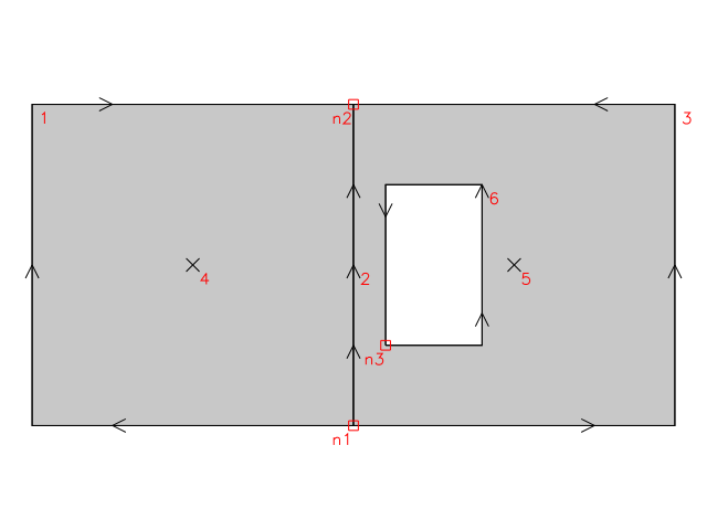
In GRASS native format:
 |   Number of points:       0               Number of centroids:  2          |
 |   Number of lines:        0               Number of boundaries: 4          |
 |   Number of areas:        3               Number of islands:    2          |
Topology dump for native GRASS format (v.build):
Nodes (3 nodes, alive + dead):
node = 1, n_lines = 3, xyz = 100.000000, 0.000000, 0.000000
  line =   3, type = 4, angle = 0.000000 (0.0000)
  line =   2, type = 4, angle = 1.570796 (90.0000)
  line =   1, type = 4, angle = 3.141593 (180.0000)
node = 2, n_lines = 3, xyz = 100.000000, 100.000000, 0.000000
  line =  -2, type = 4, angle = -1.570796 (270.0000)
  line =  -3, type = 4, angle = 0.000000 (0.0000)
  line =  -1, type = 4, angle = 3.141593 (180.0000)
node = 3, n_lines = 2, xyz = 110.000000, 25.000000, 0.000000
  line =   6, type = 4, angle = 0.000000 (0.0000)
  line =  -6, type = 4, angle = 1.570796 (90.0000)
-----------------------------------
Lines (6 lines, alive + dead):
line = 1, type = 4, offset = 18, n1 = 1, n2 = 2, left = -1, right = 1
line = 2, type = 4, offset = 87, n1 = 1, n2 = 2, left = 1, right = 2
line = 3, type = 4, offset = 124, n1 = 1, n2 = 2, left = 2, right = -1
line = 4, type = 8, offset = 193, area = 1
line = 5, type = 8, offset = 222, area = 2
line = 6, type = 4, offset = 251, n1 = 3, n2 = 3, left = 3, right = -2
-----------------------------------
Areas (3 areas, alive + dead):
area = 1, n_lines = 2, n_isles = 0 centroid = 4
  line =   1
  line =  -2
area = 2, n_lines = 2, n_isles = 1 centroid = 5
  line =   2
  line =  -3
  isle =   2
area = 3, n_lines = 1, n_isles = 0 centroid = 0
  line =  -6
-----------------------------------
Islands (2 islands, alive + dead):
isle = 1, n_lines = 2 area = 0
  line =  -1
  line =   3
isle = 2, n_lines = 1 area = 2
  line =   6
In PostGIS Topology model will be this example stored as
- 3 nodes (n1, n2, n3)
SELECT node_id,containing_face,st_astext(geom) from topo_example.node;


 node_id | containing_face |                st_astext
---------+-----------------+------------------------------------------
       1 |                 | POINT(452944.862155388 246704.260651629)
       2 |                 | POINT(453966.165413534 122105.263157895)
       3 |                 | POINT(475413.533834587 128233.082706767)
- 4 edges (3, 4, 5, 6)
SELECT edge_id,next_left_edge,next_right_edge,left_face,right_face,st_geometrytype(geom) from topo_example.edge;
 edge_id | next_left_edge | next_right_edge | left_face | right_face | st_geometrytype
---------+----------------+-----------------+-----------+------------+-----------------
       1 |             -4 |               3 |         0 |          1 | ST_LineString
       2 |              2 |              -2 |         2 |          1 | ST_LineString
       3 |             -1 |               4 |         1 |          3 | ST_LineString
       4 |             -3 |               1 |         3 |          0 | ST_LineString
- 3 faces (two areas and one hole)
SELECT face_id,st_geometrytype(mbr) from topo_example.face;
 face_id | st_geometrytype
---------+-----------------
       0 |
       1 | ST_Polygon
       2 | ST_Polygon
       3 | ST_Polygon
How to
Convert GRASS vector map into PostGIS Topology
Currently GRASS supports converting only selected vector layer into PostGIS table, not the whole vector map (see more about vector layers and maps here).
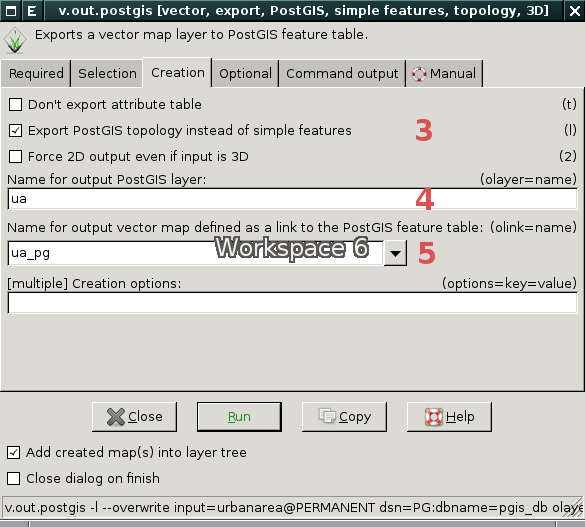
In example below GRASS vector map 'urbanareas' (layer '1' which is default) is converted into PostGIS table 'ua' located in 'pgis_db' database using v.out.postgis. Topological export is enabled by -l flag. Exported data is linked automatically as GRASS vector map by olink parameter. In this case there is no need to create a link using v.external.
From CLI:
v.out.postgis -l input=urbanarea dsn=PG:dbname=pgis_db olayer=ua olink=ua_pg
Important note: Without -l flag the vector data are exported as simple features and not as topological elements!
From wxGUI:
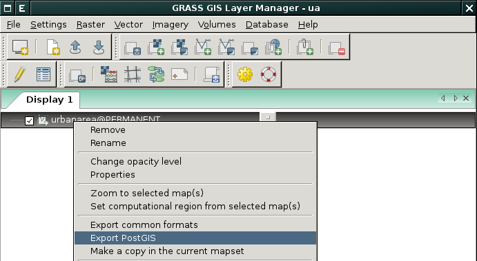
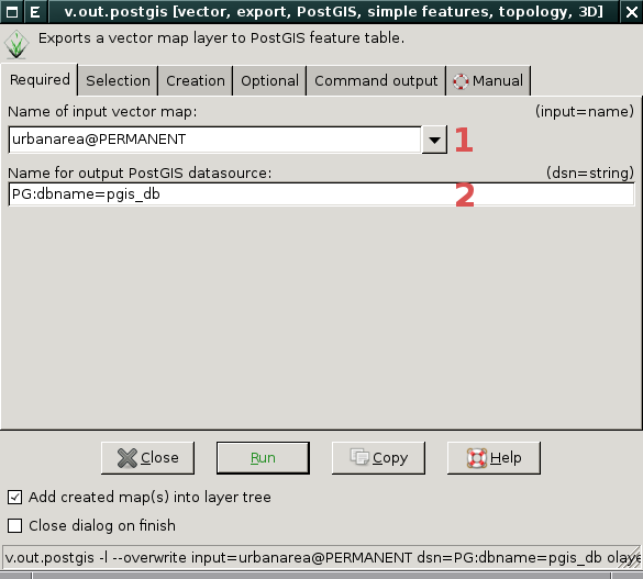 |
 |
Convert simple features into PostGIS Topology
There are two options.
First option is traditional way which requires converting vector data into GRASS topological format using v.in.our and afterwards exporting GRASS topological data into PostGIS Topology by v.out.postgis module. See example below.
v.in.ogr dsn=zone.shp
v.out.postgis -l input=zone dsn=PG:dbname=pgis_db olink=zone_pg
Second option is based on external data format set by v.external.out. In this case output format is topological PostGIS (see set output vector format to PostGIS Topology)
v.external.out dsn=PG:dbname=pgis_db options=topology=yes format=PostgreSQL
v.in.ogr dsn=zone.shp
Module v.in.ogr in this case doesn't produce vector data in GRASS format, the data are directly stored in PostGIS Topology. The module also creates vector map given by olink parameter which points to the data stored in PostGIS database.
v.info zone_pg
...
| Map format:      PostGIS (PostgreSQL)                                      |
| DB table:        public.zone                                               |
| DB name:         pgis_db                                                   |
| Geometry column: geom                                                      |
| Feature type:    polygon                                                   |
| Topology:        PostGIS (schema: topo_zone)                               |
| Topology column: topo                                                      |
Set output vector format to PostGIS Topology
Output format for vector data can be set by v.external.out.
From command line (note options=topology=yes which enables topological mode):
v.external.out dsn=PG:dbname=pgis_db options=topology=yes format=PostgreSQL
Connection settings (username, password, or hostname) can be given by db.login.
Or from wxGUI menu File → External formats → Output vector format or from toolbar ![]()
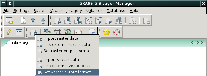
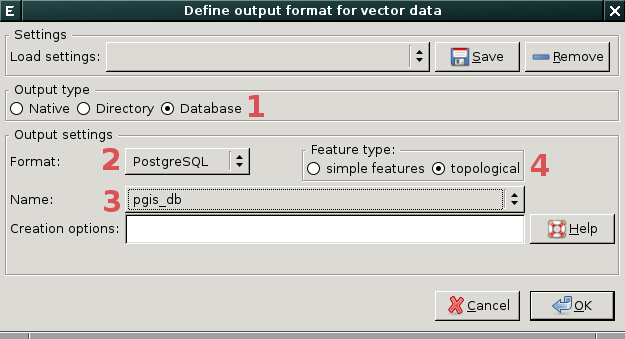
As a result, every newly created vector map will be stored in the given PostGIS Topology database. Created PostGIS data are automatically registered in the current mapset as normal GRASS vector maps (similarly when the user creates link using v.external).
Video tutorials
See also
- Working with PostGIS Topology in GRASS GIS (Seminar: Advances in GIS data processing and management at Fondazione Edmund Mach, Italy, 2013-04-13)
- v.out.postgis manual
- Working with external data in GRASS 7 and v.external.out manual
- PostGIS support in GRASS GIS
External links
- GRASS GIS
- GRASS GIS Topology manual
- PostGIS
- http://trac.osgeo.org/postgis/wiki/UsersWikiSimplifyWithTopologyExt
- PostGIS Topology manual
- PostGIS Topology wiki page
- State of the art of FOSS4G for topology and network analysis (FOSS4G 2010)
- strk's page about PostGIS
- PostGIS topology ISO SQL/MM complete (strk's blog)
- Simplifying a map layer using PostGIS topology (strk's blog)
- Concepts
- Topo-Geo-and-Topo-Net - The Concepts • Routine Details
- ISO 13249-3 Information Technology - Database languages - SQL Multimedia and application packages (Text for FDIS)