Ps.output
The ps.out try to update the standard postscript output of Grass adding new feature to design borders, graticules, categorized legends, etc
Command line flags
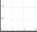
-d. Draw a 1x1 cm grid on paper to help the placement of the elements of the map.
 Example of the bottom-left corner of an A4 paper draw with flag -d.
-e. Make an output file without the postscript header. Useful when is embebed into other ps.out map.
-g. Use the extended PostScript of Ghostscript (for transparent colors)
-s. Draw the small digit of coordinate numbers in lower instead upper.
Generic Instructions
Map paper
Common elements on the map
Graticule
grid
geogrid
Map types
Raster maps: raster
Vector maps: vareas
Line maps: vlines
Point maps: vpoints
Map legends: vlegend, rlegend
Creating maps with same layout using ps.out
To make several maps with the same layout, we use three files: map_pre, map_post, and a master file. Also we need the map_# with the particular content of the map.
The master file, to repeat the creation of all maps with the same layout, is as:
 #!/bin/bash

 MAP=map_ps
 function makemap()
 {
    echo "#!/bin/bash" > $MAP
    cat map_pre  >> $MAP
    cat $1 >> $MAP
    cat map_post >> $MAP
    chmod +x $MAP
    ./$MAP $1
    rm $MAP
 }

 makemap map_1
 makemap map_2
The file map_pre include all code to execute ps.out and design the basic elements of the map: title, graticule, scalebar, north-arrow, etc. A example content is:
 OUTPUT=$1
 ps.out -g out=$OUTPUT.ps << EOF

 paper A4
    left 2cm
    top 2cm
    landscape y
    draw
      color 70:70:70
      linewidth .4mm
      rect 22cm 2cm 28cm 19cm 240:240:240
        color black
        font OffensiveBold 10 .8
        text 25cm 6cm "MAIN TITLE"
    end
 end

 scale 1:500000

 grid
    format iho
    trim -1
    major 50000
        width .18mm
        color none
    end
    minor 25000
        width .18mm
        color none
        style 2
    end
    subminor 5
    font
        name Univers
        size 10
        color black
    end
    fcolor black
 end

 vlines bz_lim
   type boundary
   label Límite del Bierzo
   lpos -1
   line
     width .3mm
     color black
   end
 end
The file map_post include the final ending code, and perhaps the common legend style. For example,
 vlegend Legend
    frame
        where 25cm 12cm
        ref center center
        offset 0 0
        border .3mm
        fcolor white
        margin 12
    end
    title
        name Univers-Bold
        size 10
        extend 1.25
    end
    font
        name Univers
        size 9
    end
 end

 EOF

 echo "GO Go go: $OUTPUT.pdf"
 ps2pdf14 $OUTPUT.ps
The file map_# include the specific code to draw the particular maps. For example,
 vareas risk_range
   label Probabilidad de infección
   legend 0
   line
     width .01mm
     color none
     style 1
    end
    fcolor GRASSRGB$.7 cat
    masked y
    setrule 1 Muy baja
    setrule 2 Baja
    setrule 3 Media
    setrule 4 Alta
    setrule 5 Muy alta
 end

 vpoint cs_parcela
    label Intensidad de ataque
    where ch_pr > 0
    symbol basic/circle
    line
        width .1mm
        color black
    end
    fcolor white$.3
    size ch_prx 8
    scale 5 2
    masked y
 end
