WMS: Difference between revisions
mNo edit summary |
mNo edit summary |
||
| (26 intermediate revisions by 4 users not shown) | |||
| Line 1: | Line 1: | ||
[[Image: | __TOC__ | ||
This page is about support of OGC web map services (WMS) in GRASS GIS. | |||
== Metasites and collections of WMS servers == | |||
* [http://www.mapmatters.org/ Extensive catalogue of OGC web map services (WMS) worldwide] | |||
* Telascience WMS services (in collaboration with OSGeo): see list at http://wms.telascience.org/ | |||
== Italian Public administration WMS == | |||
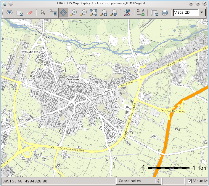
Example for public administration data imported via WMS into [[wxGUI]] | |||
[[Image:WxGUI and Piedmont (Italy) WMS.png|thumb|center|300px|City of Orbassano map]] | |||
== NASA's OnEarth WMS Example == | |||
[[Image:Akl_landsat.png|thumb|right|300px]] | |||
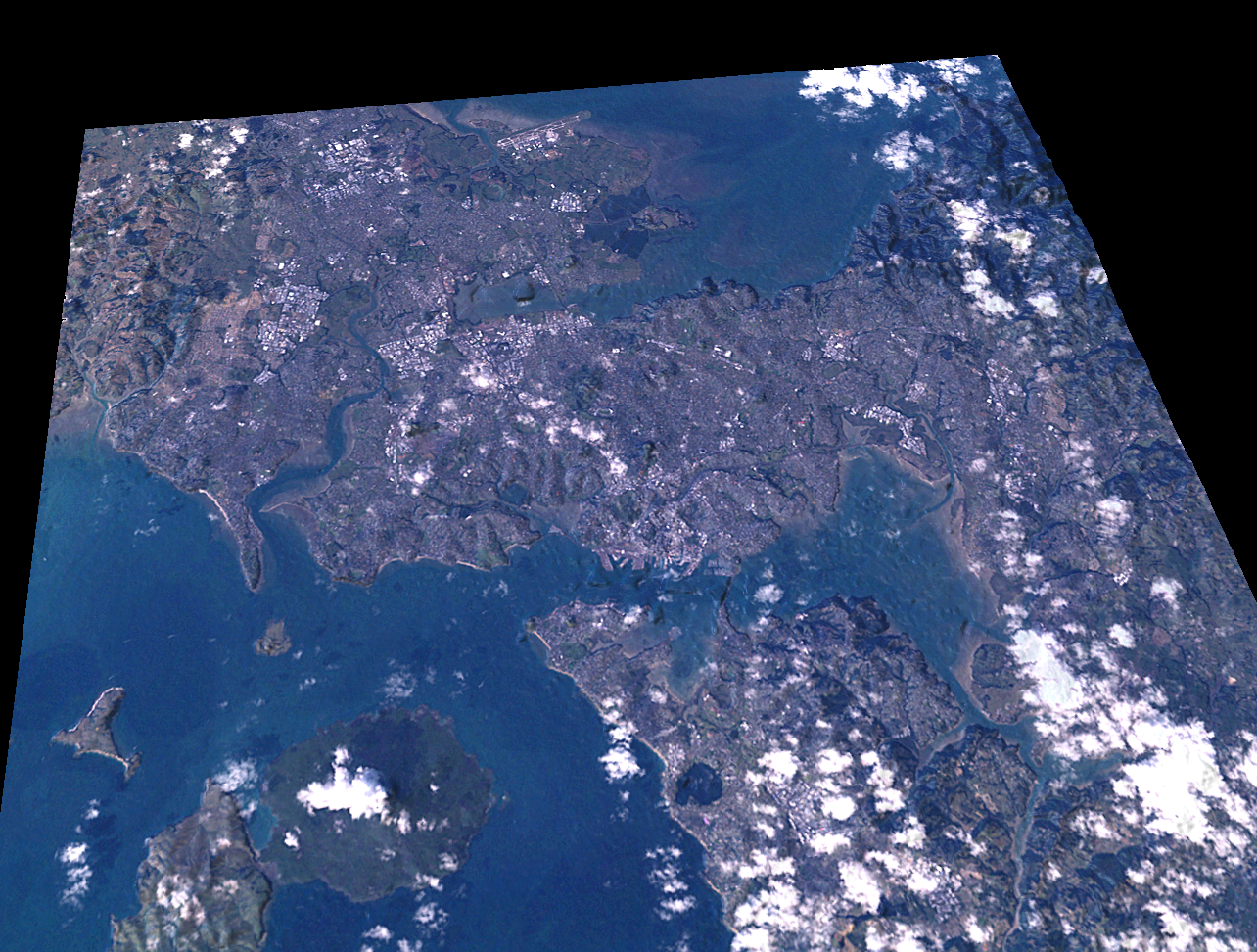
{{wikipedia|Web_Map_Service|desc=Web Map Service}} (WMS) data can be downloaded and imported into GRASS using the {{cmd|r.in.wms}} module. | |||
Mini tutorial for downloading [[SRTM]] elevation and [[LANDSAT]] imagery from [http://onearth.jpl.nasa.gov NASA's OnEarth WMS server]. | |||
Create a NZTM location (EPSG:2193) with the [[WxGUI#Location_wizard|location wizard]]. | |||
<source lang="bash"> | <source lang="bash"> | ||
# Zoom to AKL region | # Zoom to AKL region | ||
g.region n=5936130 s=5900340 | g.region n=5936130 s=5900340 w=1740030 e=1776030 res=30 | ||
</source> | </source> | ||
| Line 27: | Line 41: | ||
g.rename akl_srtm.1,akl_srtm | g.rename akl_srtm.1,akl_srtm | ||
r.colors akl_srtm color=srtm | r.colors akl_srtm color=srtm | ||
### Download and process LANDSAT: | ### Download and process LANDSAT: | ||
| Line 40: | Line 53: | ||
r.composite r=akl_landsat.red g=akl_landsat.green b=akl_landsat.blue \ | r.composite r=akl_landsat.red g=akl_landsat.green b=akl_landsat.blue \ | ||
output=akl_landsat --overwrite | output=akl_landsat --overwrite | ||
### Shaeded relief map | ### Shaeded relief map | ||
r.shaded.relief akl_strm | r.shaded.relief akl_strm | ||
d.shadedmap relief=akl_strm.shade drape=akl_landsat bright=70 | d.shadedmap relief=akl_strm.shade drape=akl_landsat bright=70 | ||
### 3D view | ### 3D view | ||
| Line 51: | Line 62: | ||
</source> | </source> | ||
In the [[NVIZ]] (or [[wxNviz]]) <tt>Visualization → Raster Surface</tt> menu set the fine raster grid size to 1. Set the vertical exaggeration to 1.0 or 2.0 | |||
== MetaCarta WMS Example == | |||
Create a NZTM location (EPSG:4326) with the [[WxGUI#Location_wizard|location wizard]]. | |||
<source lang=bash> | |||
g.region n=90 s=-90 w=-180 e=180 res=0.5 | |||
r.in.wms -c output=map \ | |||
mapserver="http://labs.metacarta.com/wms-c/Basic.py" \ | |||
layers=basic format=geotiff \ | |||
</source> | |||
== OpenStreetMap WMS Example == | |||
''Note: European coverage:'' | |||
r.in.wms url=http://watzmann-geog.urz.uni-heidelberg.de/cached/osm layers=osm_auto:all output=osm format=png | |||
r.in.wms url=http://irs.gis-lab.info layers=osm output=osm format=png | |||
See also example in {{cmd|r.in.wms}} | |||
List of Servers: http://wiki.openstreetmap.org/wiki/WMS | |||
== WMS support in GRASS 7 == | |||
{{YouTube|vfNw4SAP2Uc}} | |||
[[Category: Documentation]] | |||
[[Category: FAQ]] | [[Category: FAQ]] | ||
[[Category: Geodata]] | |||
[[Category: OGC]] | |||
[[Category: Raster]] | [[Category: Raster]] | ||
Latest revision as of 10:51, 4 December 2018
This page is about support of OGC web map services (WMS) in GRASS GIS.
Metasites and collections of WMS servers
- Extensive catalogue of OGC web map services (WMS) worldwide
- Telascience WMS services (in collaboration with OSGeo): see list at http://wms.telascience.org/
Italian Public administration WMS
Example for public administration data imported via WMS into wxGUI

NASA's OnEarth WMS Example

Web_Map_Service (WMS) data can be downloaded and imported into GRASS using the r.in.wms module. Mini tutorial for downloading SRTM elevation and LANDSAT imagery from NASA's OnEarth WMS server.
Create a NZTM location (EPSG:2193) with the location wizard.
# Zoom to AKL region
g.region n=5936130 s=5900340 w=1740030 e=1776030 res=30
If downloading for your own area, try to keep the region rows and columns smaller than the maxrow,maxcol options given to r.in.wms. Please don't abuse the server, just download small chunks.
### Download and process SRTM elevation:

r.in.wms output=akl_srtm \
  mapserver="http://onearth.jpl.nasa.gov/wms.cgi" \
  -c layers=worldwind_dem format=geotiff style=short_int \
  maxcols=1600 maxrows=1600

g.rename akl_srtm.1,akl_srtm
r.colors akl_srtm color=srtm

### Download and process LANDSAT:

r.in.wms output=akl_landsat \
  mapserver="http://onearth.jpl.nasa.gov/wms.cgi" \
  -c layers=global_mosaic_base format=geotiff style=visual \
  maxcols=1600 maxrows=1600

i.landsat.rgb -p r=akl_landsat.red g=akl_landsat.green b=akl_landsat.blue
d.rgb r=akl_landsat.red g=akl_landsat.green b=akl_landsat.blue
r.composite r=akl_landsat.red g=akl_landsat.green b=akl_landsat.blue \
   output=akl_landsat --overwrite

### Shaeded relief map
r.shaded.relief akl_strm
d.shadedmap relief=akl_strm.shade drape=akl_landsat bright=70

### 3D view
nviz akl_srtm color=akl_landsat
In the NVIZ (or wxNviz) Visualization → Raster Surface menu set the fine raster grid size to 1. Set the vertical exaggeration to 1.0 or 2.0
MetaCarta WMS Example
Create a NZTM location (EPSG:4326) with the location wizard.
g.region n=90 s=-90 w=-180 e=180 res=0.5

r.in.wms -c output=map \
  mapserver="http://labs.metacarta.com/wms-c/Basic.py" \
  layers=basic format=geotiff \
OpenStreetMap WMS Example
Note: European coverage:
r.in.wms url=http://watzmann-geog.urz.uni-heidelberg.de/cached/osm layers=osm_auto:all output=osm format=png

r.in.wms url=http://irs.gis-lab.info layers=osm output=osm format=png
See also example in r.in.wms
List of Servers: http://wiki.openstreetmap.org/wiki/WMS