V.krige GSoC 2009: Difference between revisions
⚠️AnneGhisla (talk | contribs) (CLI will come soon!) |
m (moved V.autokrige GSoC 2009 to V.krige GSoC 2009: renamed) |
||
(No difference)
| |||
Revision as of 09:05, 7 July 2009
v.autokrige: Python porting and wxPython GUI addition
Anne Ghisla's Google Summer of Code 2009 project, mentored by Martin Landa and Michael Barton
Aim of the project
As GRASS presently lacks kriging capability, it is performed via an add-on, v.autokrige, that delegates analysis to R (package automap). This module is written in ksh and has the classical autogenerated GUI. The project aims to rewrite the module in Python, creating a new GUI in wxPython that allows the user to refine parameters. I therefore plan to examinate present v.autokrige code and port it into Python, possibly improving it at the same time, and add a wxPython GUI. All time left will be dedicated to addition of further functionality, in respect of the most needed.
State of the art
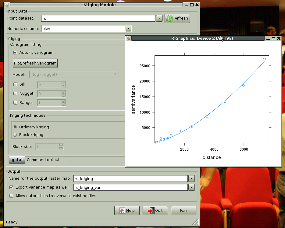
Breaking news: Ordinary kriging with gstat or automap is up and running! not all the options are available for gstat, anyway is it a great goal to see that the whole process ends in writing a GRASS raster map with the result. Note also that the module suggests a filename based on the input data map name. One step further towards the One-Click Interface.
Writing the wxPython interface, with GRASS bindings and part of R bindings - have a look at it from svn:
svn co https://svn.osgeo.org/grass/grass-addons/vector/v.krige v.krige

It is quite complete, allows the user to choose among automap (default choice), gstat (advanced functions) and geoR.
Poll: Automap and gstat pages are redundant. The underlying algorithms are for both from gstat. I therefore plan to remove automap page and set the "automatic variogram fit" checkbox in gstat's page.
These three packages are not all required; if the user already uses R for kriging, the interface will load the package(s) present in R library. If none of the packages is available a popup message will ask for installation of at least one of the packages and abort. That is, crash gracefully and with clear explanation. I know what it means to crawl among missing dependencies and I don't want my users to be puzzled by inexplicable error messages.
Question: another layout can be a Choicebox with the three packages and in respect of the choice the drawing of corresponding widgets. Opinions welcome. [Until now, all preferences went to the Notebook.]
The list of point layers is provided by VectorSelect class (gselect module) to provide uniformity of layout with wxGUI. The filtering is done once at the start of the module, then if the user adds a suitable point layer she/he will press a Refresh button to force addition to the list. Automatic refresh on popup has been tested as too time and resource consuming.
Installation
Please refer to Compile_and_Install#Scripts.
Bulletin Board
- TODOs
- Document dependencies - continue fill up html template page
- Set CLI - in progress!
- Refactor all code. Interface must be separated from model (i.e. wx from R) in order to implement CLI
- Remove automap page and move "automatic variogram fit" checkbox into gstat page, if no objection comes up
- Continue integrating gstat functions
- IDEAS TO DISCUSS
- Filter the maps after interface creation - wx.CallAfter/threads... have to grep documentation and examples
- Initial sanity checks:
- Check dependencies all before interface load. If something is missing, a popup window will give a clear message.
- Create a package to delegate dependencies check!
- Variogram fit: in a separated window, with allowed interactive model fit, using Python plot libraries.
- BLOCKING ISSUE(S)
- The big refactorisation about interface-model separation. Will quite completely rewrite the module.
Documentation
Kriging theory from Isaaks and Srivastava's "An Introduction to Applied Geostatistics" [0]. Great book.
Users feedback and other kriging software
- Call for users has been done on gfoss.it, grass-it and grass-users, r-sig-geo and r-sig-ecology mailing lists. Thanks to Giovanni Manghi and João Tiago from GFOSS.pt and Giovanni Allegri for user advices, and to Edzer Pebesma, Paul Hiemstra, Ebrahim Jahanshiri, Dylan Beaudette for support on R side.
- There are (have been) some GRASS modules that perform kriging, like:
- v.surf.krige, v.variogram: no longer developed by authors, difficult to port.
- s.surf.krig: deprecated since GRASS 6 series.
- scripts including R and spgrass6: are the concrete basis upon which build the module.
- Obtained ArcGIS availability for comparison of interface and functionality, because it is AFAIK the widespread tool used for kriging. Also Isats [1] is a valuable source of ispiration for interface design.
Planned Timeline
Draft:
- create a wxPython interface for ordinary kriging. Will follow Humane Interface rules [2].
- integrate R package automap
- midterm deadline: have a working module that performs ordinary kriging.
- integrate more R functions from gstat and geoR, giving the user the choice between gstat and geoR (kriging results vary in respect of implementation)
Weekly reports are available on SoC mailing list [3]
References
- [0] Isaaks and Srivastava, 1989: "An Introduction to Applied Geostatistics", (ISBN 0-19-505013-4)
- [1] http://www.geovariances.com/software/video-data-investigation-with-isatis-exploratory-data-analysis-ar0353.html
- [2] Jef Raskin, 2000: "The Humane Interface: New Directions for Designing Interactive Systems" (ISBN 0-201-37937-6)
- [3] http://lists.osgeo.org/pipermail/soc/