GRASS 6 Tutorial: Difference between revisions
| Line 49: | Line 49: | ||
[http://grass.osgeo.org/wiki/GRASS_6_Tutorial/Vector_data_management Working with vector data in GRASS] | [http://grass.osgeo.org/wiki/GRASS_6_Tutorial/Vector_data_management Working with vector data in GRASS] | ||
=== | ===Overview=== | ||
[http://grasswiki.osgeo.org/wiki/GRASS_6_Tutorial/Vector_data_management#Importing_Vector_data Vector Data Import] | The native GRASS vector format provides: | ||
*Vector topology | |||
*m:n mapping of geometry features to attributes | |||
*Vector layers | |||
*OGC Simple Features <-> Topological Vector Conversion | |||
*Database Management system (DBMS) | |||
*SQLite, PostgreSQL + PostGIS, MySQL, ODBC (, DBF) | |||
The vector geometry types supported in GRASS includes: | |||
*Point | |||
*Centroid | |||
*Line | |||
*Boundary | |||
*Area (Boundaries + Centroid) | |||
*Face (3D Area) | |||
*[Kernel (3D Centroid)] | |||
*[Volumes (Faces + Kernel)] | |||
All types are '''true 3D''': x,y,z | |||
The examples that follow in this section on vector data management are based on the datasets available [http://data.neteler.org/geostat2012/north_carolina here] | |||
===[http://grasswiki.osgeo.org/wiki/GRASS_6_Tutorial/Vector_data_management#Importing_Vector_data Vector Data Import]=== | |||
Revision as of 10:22, 26 July 2013
GRASS GIS version 6.4 is fully operational and stable version that can be used for production use. This tutorial will familiarize you with the improved functionality and will focus on raster and vector data management as well some basic spatial data analysis.
This tutorial is intended for GRASS GIS users who want to migrate from a previous release to the new GRASS Version. If you are a beginner, please also consider additional books or tutorials as well as consulting the Introductory Material.
Disclaimer: In case the examples described here do not work properly, you are kindly invited to send us further examples and/or code bugfixes/enhancements. Enjoy the WIKI!
NOTE: This tutorial is under construction and is incorporating sections of the previous GRASS 5.7 tutorial.
Introduction
New developments in GRASS GIS have made major improvements to the vector architecture. The most significant change includes a new 2- and 3-dimensional vector library that manages vector attributes in standard database management systems (DBMS), providing a fully relational database for vector attribute management, while preserving the flexibility of traditional GRASS topological tools. GRASS now also incorporates true 3-dimensional voxels in the NVIZ visualization environment as well as numerous enhancements to virtually every tool in the GRASS library.
If you are new to GRASS GIS and plan to use the command line inteface and/or within a Linux environment, it is recommended that you read the Introductory Material for Linux. Also, if you have been using other GIS packages, you may find the Migration tips useful reading.
Getting started
If you have already installed GRASS GIS on your system, you can continue to the next section. Otherwise, please consult the Installation Guide, which covers all of the main operating systems. If you want to compile GRASS GIS from source, you should follow these Instructions.
If this is your first time using GRASS GIS, we recommend that you download the GRASS GIS sample data, for instance the North Carolina dataset and uncompress into your GIS data directory.
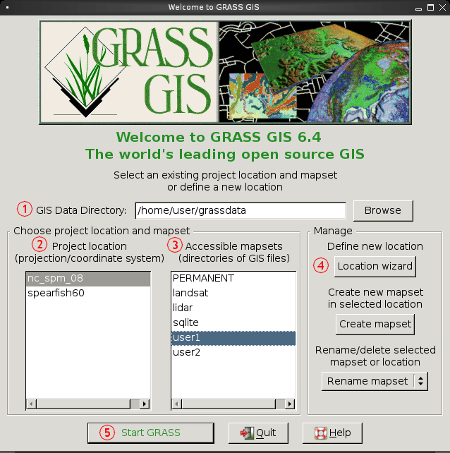
To start GRASS GIS, simply type 'grass64' on the command line. This will open the start-up window, where you will need to input and/or select the following details:
- GIS data directory
- Location (Project) name
- Mapset (Sub-project) name
Once you have selected your options, you can then click 'Start GRASS' (numbered 5 on diagram).
If you are using your own data, please consult the Location Wizard sections here.
Raster data management
Overview
This section of the tutorial is intended to provide new users with an introduction to raster data management in GRASS GIS. As with other parts of the GRASS 6 tutorial, the examples are largely based on the GRASS 5.7 tutorial as well as the GRASS GIS presentation at Geostat-2012. The aim is to present the reader with introductory information on handling raster data within GRASS GIS. It is worth mentioning that the raster management hasn't changed significantly from previous versions of GRASS (e.g. versions 4 or 5), therefore older tutorials and books on the GRASS raster modules should also work.
Raster Data Management
Vector data management
Working with vector data in GRASS
Overview
The native GRASS vector format provides:
- Vector topology
- m:n mapping of geometry features to attributes
- Vector layers
- OGC Simple Features <-> Topological Vector Conversion
- Database Management system (DBMS)
- SQLite, PostgreSQL + PostGIS, MySQL, ODBC (, DBF)
The vector geometry types supported in GRASS includes:
- Point
- Centroid
- Line
- Boundary
- Area (Boundaries + Centroid)
- Face (3D Area)
- [Kernel (3D Centroid)]
- [Volumes (Faces + Kernel)]
All types are true 3D: x,y,z
The examples that follow in this section on vector data management are based on the datasets available here
Vector Data Import
Below are from the GRASS-5.7 Tutorial -- but are being updated...
Vector network analysis examples
- New Spearfish examples: v.net, v.net.iso, v.net.path etc.
- Old tutorial: http://grass.osgeo.org/grass57/tutorial/network.html
Vector overlay/clipping examples
http://grass.osgeo.org/grass57/tutorial/vectoroverlay.html
Usage examples
The following await porting from the GRASS 5.7 tutorial
Basic usage examples
http://grass.osgeo.org/grass57/tutorial/ex_basic.html
Complex usage examples
http://grass.osgeo.org/grass57/tutorial/ex_complex.html
Examples from US National Atlas
http://grass.osgeo.org/grass57/tutorial/usa_demo.html
FAQ (Frequently Asked Questions)
Troubleshooting
http://grass.osgeo.org/grass57/tutorial/troubleshooting.html
- Grass Six Tutorial Troubleshooting
Links of interest
- GRASS-GMT Examples: http://169.237.35.250/~dylan/grass_user_group/
Further reading
GRASS and R kriging interpolation
Mini How to interpolate using kriging with GRASS and R
How to interpolate point value using kriging method with R and GRASS 6
References
- GRASS books and tutorials
- GRASS 6 Tutorial: http://www.gdf-hannover.de/literature
- Translation Portal for GRASS 6 Tutorial http://www.gdf-hannover.de/translation
