IALE - North America 2021
Jump to navigation
Jump to search

This page is about work related to GRASS GIS presented at IALE - North America 2021 Annual Meeting, Virtual, April 11-15, Reno, Nevada, USA, the conference of the North American Regional Association of the International Association for Landscape Ecology.
Presentations
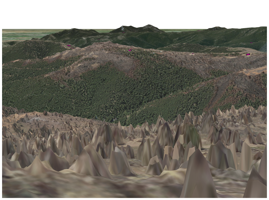
Temporally Dynamic Viewscapes for Modeling the Visual Amenities of Exurban Housing Development
- Session: Landscape Change
- Speaker: Nicole Inglis (Speaker) PhD Candidate, North Carolina State University
- Authors: Nicole Inglis, Center for Geospatial Analytics, NC State University, Jelena Vukomanovic, Department of Parks, Recreation, and Tourism Management, NC State University
- Description: In the American West, low-density exurban residential development is reshaping rural landscapes. Exurbanization is driven in part by landscape aesthetics, rural character and perceived quality of life, and can fundamentally alter ecological, political and social landscapes. Viewscape analysis—exploration of the visible 3-dimensional portions of terrain with which people form a connection—allows us to quantify visual characteristics and understand how they interact with other landscape attributes to shape exurban development. However, the extent to which viewscapes change over time due to anthropogenic and natural processes—such as wildfire or housing development—has largely gone unaccounted for in development models. In this study, we examine the relationship between visual quality and exurban housing development over time in the amenity-rich mountain landscape of Boulder County, CO. We compute viewscape metrics (area, land cover, terrain ruggedness and visible neighbors) from exurban houses using LiDAR-derived digital surface models reflecting fire-driven vegetation changes and housing development between 1990 and 2015. Combined with other development drivers, such as distance to roads, rivers, lakes and urban centers, we conduct a survival analysis to quantify where and when exurban development is shaped by visual quality and landscape drivers. The evolution of viewscapes in exurbanizing regions is an iterative loop, where visual quality shapes landscape preferences and development patterns, which alters future visual quality, which in turn shapes the preferences and behaviors of visitors, residents and new migrants. Amid the COVID-19 pandemic, insights from the real estate industry indicate that the proliferation of remote work opportunities and broadband advances are spurring the next wave of urban-to-rural migrants. Temporally dynamic insights fulfill a growing need in rapidly exurbanizing landscapes where communities are grappling with the complex and novel dynamics introduced by exurban migration.
- Relevance to GRASS GIS: Viewscapes and associated metrics computed in GRASS GIS in a high-performance computing environment. Highlighted module: r.viewshed.
Applying Local NOAA sea level rise temporal model estimates to connected estuarine areas to estimate inundation impacts on wildlife habitat
- Session: Remote Sensing of Large-Scale Changes and Disturbances over Broad Landscapes
- Author: Doug Newcomb (Speaker) Cartographer, USFWS
- Description: Conservation planning involves evaluating both current and future species habitat conditions. Potential changes in coastal habitat conditions include assessing predicted sea level rise over the time frame of the planning effort. NOAA temporal sea level rise models have been created for specific locations on the seashore of North Carolina at specific points, but these estimates have not been extended at a broad scale in the inland estuaries of North Carolina. In this presentation, the NOAA local model results for the North Carolina Coast and adjoining states are extended using GRASS GIS to create 55 billion pixel raster 1.524m (5ft) resolution bathtub models to cover the North Carolina coastline and estuaries and adjoining Virginia estuaries for the NOAA Intermediate Low, Intermediate, Intermediate High, High, and Extreme sea level rise scenarios for 2040, 2060, 2080 and 2100 and are compared to existing species habitat data.
- Relevance to GRASS GIS: GRASS GIS used for most of geospatial analysis.
Empirical Global Fire Regimes Identify Common Fire Relationships Across the Planet
- Session: Exploring the context and implications of departures from historical fire frequency across ecosystems
- Authors: William Hargrove, USDA Forest Service, Jitendra Kumar, ORNL, Steve Norman, USDA Forest Service, Forrest Hoffman, ORNL
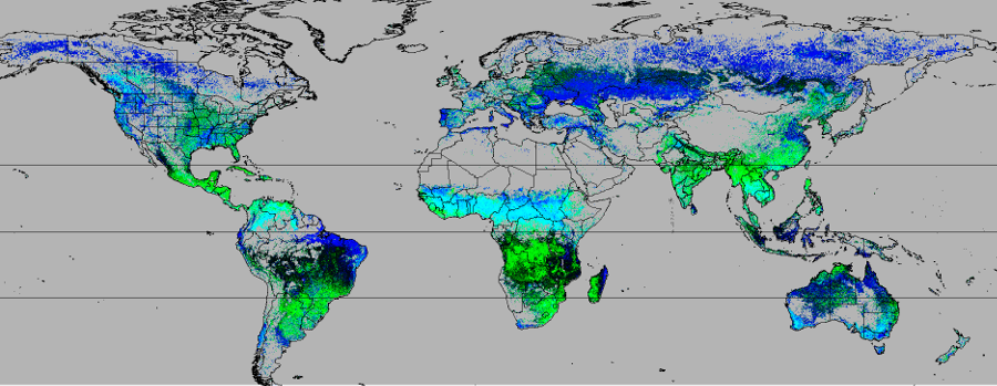
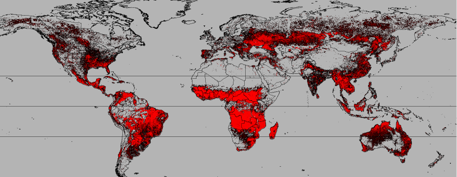
- Description: Occurrence and behavior of fires are governed by climatic conditions, type and availability of fuels, and ignitions. Understanding the seasonality, frequency, intensity and severity of fires is critical for managing the landscape. More than 83M MODIS “hotspot” thermal detections from 2002-2019 were grouped into 10km cells, and 21 derived variables describing fire characteristics of intensity, return frequency, and seasonality within each cell were developed and subjected to unsupervised multivariate geographic clustering to delineate Global Fire Regimes (GFRs). Locations within each GFR have similar combinations of the 21 fire characteristics. Both human-caused and wildfires were included. A seasonal date transform allows, say, “summer fires”, to be grouped together, despite having started in different calendar months in the northern and southern hemispheres. The same GFR can be split across geographic distances, so long as the 21 aggregated MODIS hotspot fire characteristics are sufficiently similar. A few GFRs are unique, but the majority are shared, no matter how the world is divided. An annual timeline for each GFR shows the top six biweek periods having greatest fire frequencies. Most Global Fire Regimes (GFRs) had two annual modes of maximum fire frequency, often at the beginning and end of the growing or rainy season. GFRs having more high frequency modes indicate swidden agriculture and deforestation. Location Groups, formed by “training” on GFRs in a particular location and then observing occurrences elsewhere, highlight all other global locations sharing the same recognizable types of fire. Like ecoregions, GFRs have practical utility for identifying all other global areas that have similar fire characteristics. The season-synchronizing date transform can also be used to compare other types of phenological events across hemispheres. Because they are widely shared geographically, GFRs can direct the spatial transfer of ecological insights about fire, and can facilitate the exchange of successful fire management strategies worldwide.
- Resources: HTML Slides
Iterative Near-term Ecological Forecasting for Biological Invasions using the PoPS (Pest or Pathogen Spread) Platform
- Session: Forecasting Biological Invasions
- Speaker: Chris Jones (Speaker) Research Scholar, NC State University Center for Geospatial Analytics
- Authors: Chris Jones NCSU, Shannon Jones NCSU, Anna Petrasova NCSU, Vaclav (Vashek) Petras NCSU, Devon Gaydos USDA APHIS, Megan Skrip NCSU, Ben Seliger NCSU, Yu Takeuchi NCSU, and Ross Meentemeyer NCSU
- Description: Ecological forecasting has vast potential to support environmental decision-making with repeated, testable predictions across management-relevant timescales and locations. Yet, resource managers rarely are engaged to co-design forecasting systems or embed them in decision-making. Predicting the outcomes of planned management is particularly important for biological invasions, to optimize when and where to allocate resources. Yet, spatial-temporal models of spread have not typically been openly shared, iteratively updated, or interactive to allow exploring management actions. We describe a species-agnostic, open-source framework –– called the PoPS (Pest or Pathogen Spread) Forecasting Platform –– for co-designing near-term iterative forecasts of biological invasions. We highlight the potential for PoPS to improve management outcomes using case studies of one pest and one pathogen: spotted lanternfly (SLF, Lycorma delicatula) and sudden oak death (SOD, Phytophthora ramorum). We also show how iterative calibration with new data improves model skill, as measured by accuracy assessments that capture spatial patterns. Additionally, for SLF we highlight how new scientific knowledge, specifically the effect of temperature on SLF egg hatch, is incorporated into the model and how forecasts incorporating new discoveries are compared to previous forecasts and hindcasts to determine the effect of new information on model performance and realism. The PoPS framework is a primary example of an ecological forecasting system that has been both scientifically improved and optimized for real-world decision-making through sustained participation and use by management stakeholders and by iteratively updating forecasts as new data become available.
- Relevance to GRASS GIS: Presented PoPS model is available through r.pops.spread module in GRASS Addons.
Hurricane Michael: remote sensing-based assessment of vegetation damage, severity and recovery
- Session: Remote Sensing of Large-Scale Changes and Disturbances over Broad Landscapes
- Speaker: Jitu Kumar (Speaker) Research Staff Member, Oak Ridge National Laboratory
- Authors: Jitendra Kumar (Oak Ridge National Laboratory), William W. Hargrove (USDA Forest Service), Steven P. Norman (USDA Forest Service), William M. Christie (USDA Forest Service)
- Description: Hurricane Michael made a landfall in the Florida panhandle in October 2018 as one of the strongest hurricanes in the continental United States in recent history. With maximum sustained winds of 257 km/h, Hurricane Michael caused devastation across Florida, Georgia, and Alabama. Strong winds uprooted and snapped trees, damaged tree crowns and led to a considerable financial damage, estimated at almost $1.3 billion, to regions important timber industry. Hurricane winds also caused significant damage to croplands (like cotton), and other agricultural operations. We analyzed time series of high resolution remote sensing imagery from Sentinel-2 platform to assess extent and severity of disturbance to vegetation. Using pre- and post-hurricane imagery we quantified the change in the vegetation indices as an indicator of disturbance. Using field based observations from vegetation damage surveys, we built a model to translate remote sensing derived reduction in vegetation greenness to disturbance severity. This remote sensing based study helps assess the impact of hurricane at landscape scale across all vegetation types, not limited to just the regions or vegetation types surveyed. By continued tracking of vegetation during post-hurricane, we also studied the patterns of recovery of the vegetation. Recovery patterns show significant variability across vegetation types, such as forest vs croplands, and disturbance severity.
- Relevance to GRASS GIS: GRASS GIS used for most of geospatial analysis.