File:Wxgui computational region set from raster.png
Jump to navigation
Jump to search
No higher resolution available.
Wxgui_computational_region_set_from_raster.png (453 × 186 pixels, file size: 39 KB, MIME type: image/png)
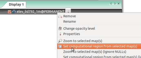
Setting computational region (extent and resolution) based on a raster in Layer Manager in wxGUI (GRASS GIS 7.0)
File history
Click on a date/time to view the file as it appeared at that time.
| Date/Time | Thumbnail | Dimensions | User | Comment | |
|---|---|---|---|---|---|
| current | 13:53, 24 March 2017 | 453 × 186 (39 KB) | ⚠️Wenzeslaus (talk | contribs) | Setting computational region (extent and resolution) based on a raster in Layer Manager in wxGUI (GRASS GIS 7.0) |
You cannot overwrite this file.
File usage
The following 7 pages use this file:
- Analytical data visualizations at ICC 2017
- Analytical data visualizations at ICC 2017/es
- From GRASS GIS novice to power user (workshop at FOSS4G Boston 2017)
- Processing lidar and UAV point clouds in GRASS GIS (workshop at FOSS4G Boston 2017)
- Processing lidar and UAV point clouds in GRASS GIS (workshop at FOSS4G Boston 2017)/es
- Unleash the power of GRASS GIS at US-IALE 2017
- Unleash the power of GRASS GIS at US-IALE 2017/es